
Drones Saving Lives During Emergencies From Storms
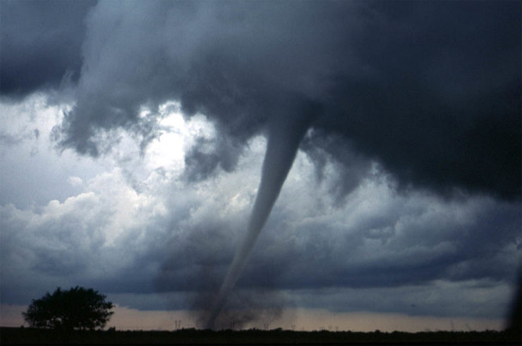 Hurricanes and cyclones are difficult to predict. About three quarters of hurricane warnings turn out to be false alarms, but when tornadoes do occur, people generally have less than 15 minutes to prepare for the impeding storm. To help make more accurate predictions, as well as add to this lead time, meteorologists are now flying unmanned aerial vehicles or drones directly into storms to get valuable information regarding tornadoes before they cause havoc to people and their property. This is proving to be quite successful as far as the objective is concerned.
Getting Inside the Storms
Scientists agree that little is known regarding the formation and development of tornadoes. Satellite measurements predominantly used by scientists generally give a good indication of the precipitation and atmospheric temperature characteristics of storms. However, the measurements are often too crude to assist in demystifying the formation and development of storms. Satellite measurements and even manned storm chaser aircraft hardly collect data of the crucial area immediately above ocean waters. The manned storm chaser aircraft never fly below 5,000 feet and the pilots choose to remain at least 10,000 feet high, which is well above the atmospheric conditions that affect us most.
Consequently, meteorologists miss out on critical data regarding the progression of storms. For instance, the 2004 Hurricane Charley caught observers and residents by surprise when it strengthened from Category 2 to 4 within 3 hours prior to landing and caused devastation in Punta Gorda. Drones are now being flown into the tornadoes to get lifesaving data so that storms like Charley do not catch people by surprise. The NOAA (National Oceanic and Atmospheric Association) successfully tested some inexpensive drones known as Coyote by flying them into Hurricane Edouard and analyzing the data gathered. Basically, drones help scientists get inside storms and gather data which can be relayed to observation centers hundreds of miles away in real time. The meteorologists then work to identify characteristics of the storms.
Low Altitude Measurements
Apart from being largely inexpensive, the main advantage of drones is that they can fly at low altitudes where they’re able to gather much more detailed data compared to satellites, manned aircraft and parachute sensors. The low altitude measurements help meteorologists get a real-time glimpse into a storm’s epicenter. This way, the drones are enhancing hurricane prediction models and enabling precise forecasts. Other drones used by the NOAA include the Whimbrel, which is still at the development stage, and NASA’s military grade Global Hawk drone that is used to detect stormy conditions in the Atlantic Ocean.
Drones have become lifesaving weather instruments as they are being developed to make weather warnings more accurate and help afford more time for people to take cover. Indeed, inaccurate warnings cause people not to take precaution at all even when the danger is real because they’re used to false tornado warnings. With greater accuracy however, more lives would be saved as people will take these warnings more seriously and will have more time to prepare. Arguably, drones are far from perfect, but they are light years ahead of the technologies we have in place today. With time, drones are going to be able to roam the skies in a highly organized manner, relaying back crucial information in real time.
|