
Lost Underwater Continent, “New Zealandia”, Mapped Out With the Help of Water Drones
World Data Center for Geophysics & Marine Geology/National Geophysical Data Center, NOAA
As children in grade school, we learn that the Earth is made up of seven landmass continents, Africa, Antarctica, Asia, Australia, Europe, North America, and South America. We were also taught that these continents were at one time part of a larger landmass that has been separated due to geological changes that took place millions of years ago. But, seeing how little we know about what lies beneath the Earth’s oceans and the continued advancement of technology, it should come as no surprise that not long ago a new continent was discovered submerged under the Pacific Ocean.
In 1995, geophysicist and oceanographer Bruce Luyendyk officially named a continental fragment that had been submerged under the ocean some 23 million years ago, New Zealandia. After much research and the assistance of some drones, New Zealandia was upgraded from a micro-continent to a full-fledged continent in 2017. Now scientists have released new maps compiled from drones to fully understand New Zealandia. This was made possible when in 2017 the United Nations Ocean Conference announced a collaborative mission to map the entire ocean floor between the General Bathymetric Chart of the Oceans (GEBCO) and the Nippon Foundation of Japan. The program went on to be called Seabed 2030, the year by which they hope to complete their mission. As of now, Seabed has successfully mapped 20% of the Earth’s ocean floor. As explained on their website, “Knowing the depth and shape of the seafloor (bathymetry) is fundamental for understanding ocean circulation, tides, tsunami forecasting, fishing resources, sediment transport, environmental change, underwater geo-hazards, cable and pipeline routing, mineral extraction, oil and gas exploration and development, infrastructure construction and maintenance and much more.”
Though under the umbrella of GEBCO and the Nippon Foundation, Seabed finds help from numerous oceanic research firms from all over the world. The organizations are all sharing the data they collect and making it public, to compile a total picture of the ocean floor. One of the best tools available for this mission is a drone called Saildrone. According to their website, “A saildrone is an unmanned surface vehicle (USV) that combines wind-powered propulsion technology and solar-powered meteorological and oceanographic sensors to perform autonomous long-range data collection missions in the harshest ocean environments.” Weighing 750 kilograms, the Saildrone looks like a 7 meter long surfboard with a 5 meter tall sail atop of it. It can be launched and retrieved from any dock in the world and travel up to 100 killometers a day at speeds between 3-8 knots. Fully autonomous, the Saildrone can stay in the water for up to a year collecting data as it is fully powered by solar panels and wind propulsion.
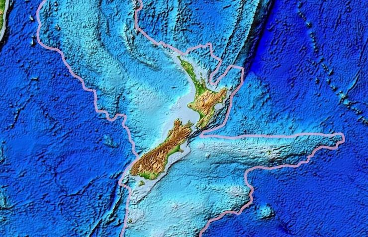
A Saildrone can be equipped with a wide range of data collecting sensors. It can collect both atmospheric and oceanic measurements, including tectonic and bathymetric readings to create in-depth maps of the ocean floor. Using drones to collect data, Seabed provided the tectonic and bathymetric research to GNS Science, New Zealand’s
Earth, geoscience, and isotope research center. GNS compiled the research into interactive maps that are available to the public to shed light on just how vast New Zealandia is. While 95% of its landmass lies underwater, we now know that New Zealandia stretches nearly 2 million square miles along the seafloor, more than half the size of Australia. Nick Mortimer, a geologist from GNS, said that these maps will help better understand the region of the southwest Pacific. As to New Zealandia’s reclassification as an actual continent, this clarification would have been made long ago if it wasn’t for the ocean hiding its mass Nick points out. Now, thanks to data collected by drones, Te Riu-a-Māui, the Maori name for New Zealandia, is receiving the recognition it deserves as Earth’s 8th continent.
|