
Professor From School of Engineering at York University Using Drones to Research Landslides
The Earth is in a constant state of change. For the most part, these changes are too far below the ground and small for us to feel. The National Earthquake Information Center reports that there are about 12,000-14,000 earthquakes each year around the world. Most of these are at a Magnitude of 2 and aren’t even noticed. Earthquakes aren’t the only natural, frequently occurring phenomenons that change the landscape of the Earth. Landslides are drastic changes that happen all the time and can cause serious damage. According to the United States Geological Survey, landslides kill between 25-50 people and cause billions in damages each year. Many factors contribute to a landslide event, including small earthquakes and over urbanization. Predicting a landslide event is not an exact science, though new technologies are easing the burden.
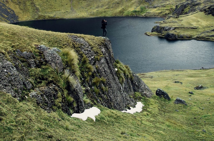
Some researchers have been turning to drone technology to help create predictive landslide models. Civil Engineering Professor Ryley Beddoe of the Lassonde School of Engineering at York University in Toronto decided to study landslides after being struck by the number of landslide slopes she noticed on a canoeing trip. She realized that the best way to learn how landslides happen is by getting out of the lab and collecting data on already existing slopes. With her students and a drone in hand, she headed out to the Scarborough Bluffs along the shoreline of Lake Ontario. Because of the prime real estate looking over the lake, there has been a boon in construction in the area. This has led to The Bluffs having rapidly eroded from landslides. With her drone, Professor Beddoe captures detailed images of the slopes left behind by landslides. The data collected is then turned into digital elevation models. As Professor Beddoe said, the models “allow us to better understand not only a failure if its happened, we’re actually looking at a landslide, but it also allows us to look at the geometry, the topography, without actually having to be out there to measure in the field.”
Without a drone, Professor Beddoe says it would be extremely difficult and dangerous to collect the data from the slopes. It would mean having to climb the rocky, unstable face of the slope that could be at a 45-90 degree angle. The drone takes the place of having to be an experienced climber while still collecting valuable data. Once a baseline model is built from the drone images, Professor Beddoe returns to the site to collect more drone images over a period of time. These images then help her understand how the slope changes. “If something happens that’s out of the ordinary we would see that,” she says. “We would actually be able to build a repository of sorts of how these slopes are changing and evolving. And that allows us to better predict when a larger catastrophic event may actually happen.”
The drone that Professor Beddoe purchased for her research in 2016 was an off the shelf DJI Inspire 1. DJI has since retired this model and replaced it with a range of drones which are more advanced. But back in 2016, Inspire was the ideal choice for Professor Beddoe. The drone was lightweight and easy to fly. It came with a high definition camera on a gimbal that allows images to be captured from any angle. Many other researchers around the world have begun using drones to study landslides in similar fashions. Meanwhile, in Hong Kong, the Civil Engineering & Development Department’s Geotechnical Engineering Office has started a 3 year program using drones to reverse damage left in the wake of landslides.
One way to help prevent the reoccurrence of a landslide is to stabilize the ground with vegetation. Having to manually replant a landslide slope would be extremely time consuming and expensive. Often the slopes are in hard to reach places making it dangerous or impossible for manual crews to even reach. The Civil Engineering & Development Department is taking inspiration from how ecological conservationists are using drones to replant forests. Special seed pods are loaded into a seeder suspended from a drone. The seeds are encased in soil with a blend of nutrients to help healthy plants growth. The drone flies over the designated area and shoots out the seed pods. The combination of the force of propulsion from the drone and gravity ensures that the seed pods successfully embed into the ground soil.
Rapid urbanization has led to an increase in landslides throughout the Hong Kong region. The Civil Engineering & Development Department plans to use drones to reseed landslide slopes at Shek Kong, Ta Shek Wu, and Fan Kam Road. The hope is that within 3 years there will be evidence of enough new plant growth to begin using the drones to replant elsewhere, improving the stability of natural terrains. Landslides happen all over the world regularly. In many cases, there is nothing that can be done to prevent them. However, with advancing drone technology, researchers can better understand them and undo the damage they create. As Professor Beddoe said, her goal in using drones to understand landslides is so that she can “tell people that they live somewhere safe and that they are going to be safe. And for those who are in areas that might be at greater risk, that they also know that, and we can better prepare them and better predict when that risk will happen.”
|