
Raytheon Technologies Builds the “Coyote” Drone That Can Be Flown Into Storms to Gather Data for Researchers and Meteorologists
© Raytheon
The now defunct company Advanced Ceramic Research from Tucson, AZ was the first to start developing the Coyote drone. After several corporate changeovers, the company was bought by Raytheon Technologies, who completed the development of Coyote. The drone was introduced in 2014 with the primary purpose of supporting The United States of America’s Army and Airforce. The drone was to be used in missions such as reconnaissance, surveillance, and intelligence.
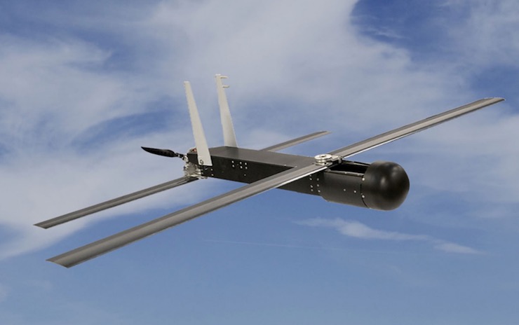
The Coyote was designed to be an expendable drone as it would complete a mission without the goal of returning to base. Because of this, it was not long until researchers from the National Oceanic and Atmospheric Administration (NOAA) realized that the Coyote was perfectly suited to gather data for meteorological purposes. The Coyote weighs 13lbs, is 36 inches long, and has a 58 inch wingspan. It can remain airborne for hours at a time and is sturdy enough to handle extreme weather conditions. It is launched from a tube on the ground, a ship, or from a plane. Once launched, the drone’s wings extend and it can be remotely or autonomously operated. Each Coyote costs around $20,000 making it an affordable expendable drone for government use.
Before the advancement of drones like the Coyote, NOAA would fly a plane high above a storm and drop atmospheric data collecting devices down into the storm. This always put the pilots at risk, many of the devices would miss their mark. Not to mention, the devices could only gather snapshots of information. The Coyote’s first deployment was in 2014 when it was launched from a plane, a safe distance away from Hurricane Edouard. The drone was piloted to an altitude of about 400ft to reach the treacherous lower levels of the storm. Storm data was collected, but the primary point of this mission was to test the durability and range of the drone.
After some fine tuning, the Coyote was ready for the 2017 hurricane season. From September 22-24, 2017, NOAA with the help of Oak Ridge Associated Universities atmospheric scientist Ron Dobosy and drone pilot Ed Dumas, Coyote drones were sent out into Hurricane Maria for six flights to collect storm data unlike any that had ever been collected before. For the first time, researchers had a tool that they could control inside of a storm. Not only were they able to control the drone, but the drone was able to stay with the storm long enough to give Dobosy and NOAA information like storm strength that had previously been a mystery to meteorologists.
“It is kind of exciting because there’s an area in a hurricane that if you go there, you don’t live to tell about it,” Dobosy said. “It’s underneath the eyewall, low altitude over the ocean. These aircraft are designed to go there.” Before crashing into the sea, the drones wirelessly transmitted data back to NOAA’s National Hurricane Center. The data the Coyotes collected during Hurricane Maria is still being analyzed and compared to other data sets today, often to help in real time scenarios.
Information on storm strength is particularly important. Meteorologists can make predictions as to the path of a storm, but they had not been able to accurately predict a storm’s intensity. Because the drone was able to position itself in the eye of the storm for an extended period of time, how storms build in strength can now be assessed. The data provides meteorologists with a model to better predict the outcome of a storm’s intensity. This can then be used to prepare communities for protection or the necessity to evacuate to safer ground. Meteorology has always been an imperfect science. The weather can drastically change from many variables. But, with tools like drones that can collect atmospheric data better than ever, weather prediction can be managed with greater detail.
|