
Two Researchers from the University of Hong Kong Created a Drone Called the “Laser Raptor” to Help Locate Buried Fossils
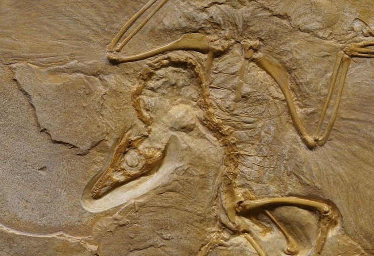
In the more than 4 billion years since there has been life on Earth, our planet has gone through some dramatic changes. Fossils found in Greenland dating back to 3.7 billion years ago show the earliest known life forms on Earth, simple anaerobic organisms. Around 900 million years ago, life forms began to evolve as have been traced through dated fossils. Paleontologists study these ancient fossils to learn how life forms survived and evolved to better understand our ever-changing platnet. For hundreds of years, civilians and trained professionals have been finding fossils around the world. Many by chance and some through careful hypothesis and searching. Over time, technology has made the search for these ancient clues more accessible. Now as we enter an age of highly developed drone technology, locating fossil remains is becoming even easier.
In a collaboration between the University of Hong Kong’s (HKU) Research Assistant Professor Dr. Michael Pittman of the Vertebrate Paleontology Laboratory, Division of Earth & Planetary Science and Department of Earth Sciences and the Director of the Foundation for Scientific Advancement, Thomas G. Kaye, a new drone has been developed that can literally fly over a plot of land and tell researchers if there are fossils hidden below. Drones have long been useful for surveying and creating detailed maps. When equipped with cameras, GPS, LiDAR, or other sensors, a drone can quickly scan and compile data that translates into detail rich and accurate maps. In essence, that is exactly what Pittman and Kaye have done with the drone which they have dubbed “Laser Raptor”.
Mounted onto the lightweight Laser Raptor is a stabilized HD camera and LiDAR tracking system. But what makes the system for this drone particular is that it also has a laser that emits a fluorescent beam to scan for fossils. Fluorescence is known to cause fossils to illuminate in the dark, making them easier to distinguish. Pittman and Kaye developed a technique of using this principle called Laser-Stimulated Fluorescence (LSF) attached to a drone. With the drone, LSF technology can be applied to a wide area quickly, while using a minimal power source.
To test out their prototype, Pittman and Kaye headed out one of the world’s richest known fossil beds, the Badlands of Arizona and Wyoming. A protected US National Park spanning 244,000 acres where thousands of fossils from hundreds of species have been uncovered. Now it is home to many prairie native animals, including the highly endangered black-footed ferret. Because of its status as a national park and is the home to an endangered species, Pittman and Kaye had to first obtain specialized permission from the FAA to test their drone. Added to the exemption granted by the FAA was the ability for the drone to be flown at nighttime.
Before launching the drone at night, Pittman and Kaye programed the Laser Raptor to fly through a specific grid. The drone’s LiDAR system would ensure the flight path and a predetermined altitude was maintained at all times. Once the sky was dark enough for the LSF system to work, the Laser Raptor was released. As explained in an abstract written by Pittman and Kaye, “A near‐UV laser is projected across the ground as a horizontal line directly below the UAV. Co‐mounted with the laser is a small highly sensitive video camera stabilized on a motion‐controlled gimbal that records the laser line during the flight. An intermittent, powerful white light strobe flashes during the flight to record the UAV’s ground position in the scanned area.” At the end of the mission, the drone autonomously returns to base and all the collected data is processed.
The results from the LSF mounted drone was better than expected. Not only did the fluorescent light show where fossil remains were located, but it was able to show specific details like skin and cartilage. The drone system also gave the team a detailed map of where the fossils were hidden, leading them to within inches of newly uncovered fossils. While a drone equipped with LSF can clearly have a great impact on paleontology and archeology, it also shows great promise for geological studies both on Earth and other planets. As Pittman and Kaye state in their research, “With centimeter resolution and the geochemical differences shown via fluorescence, this system will increase the scale and efficiency of data collection involving fossils, rocks, and minerals including mineable materials, fluorescent organisms including biogenic mineral producers like shellfish as well as archaeological artifacts. Thus, the fields of evolution, ecology, Earth and planetary science, archaeology and other subjects involving fluorescent targets would all benefit from this new system.”
|