
Using Drones to Monitor Volcanoes and Lava Flow on the Islands of Hawaii
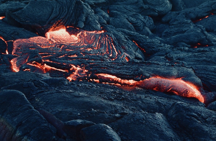
Rising 4,091ft above sea level Kilauea is the most active of the five volcanoes that make up the big island of Hawai’i, Hawaii. Geologists estimate that the volcano formed between 210,000 and 280,000 years ago and rose above the sea level 100,000 years ago. The volcano was in a nearly constant state of eruption from 1983 to 2018. Most of the volcano’s activity has been mild, though it had been known to damage some nearby properties. Still, it has been a major tourist attraction for the island of Hawai’i as its moderate eruptions allow for people brave enough to get close to the flowing lava.
In March of 2018, the Hawaiian Volcano Observatory (HVO) noticed a change of increased pressure building within Kilauea and warned of the possibility of an explosive eruption. Over the coming weeks, evacuation plans were enacted as one of the crater floors collapsed and lava began breaching the safe zone. This was followed by hundreds of small earthquakes over the following days accumulating with a 6.9 magnitude quake on May 4, 2018. By the end of June, nearly 700 homes and properties were destroyed by a combination of earthquakes and explosive eruptions. The amount of lava that flowed out of Kilauea from May to August of 2018 was enough to fill 320,000 Olympic sized pools.
Throughout the 2018 eruption of Kilauea, drones were on hand to assist emergency responders daily. Because of the ash in the air, flying a manned airplane or helicopter over the region was not safe. A team from the University of Hawaii, Hilo led by graduate student Rose Hart spent every day scanning the area with drones once the volcano began erupting. The previous year, Rose won an Excellent Award from the Forum Math For Industry conference in recognition of her work with drones. She had been using drones to map coastal erosion at Hapuna State Beach Park, Hawai’i. Though accustomed to using her drone during daylight hours for research, Roes, her team, and drones were perfectly adept for monitoring the dark ash filled skies.
While there are a handful of geologists and volcanologists that use drones to regularly study volcanoes, that is not what Rose and her team were doing in 2018. Rather, they were using the drones to follow the lava flow so emergency plans could be made if necessary. Flying at an altitude of around 100 meters, the drones would take pictures of the lava paths every hour. The images were then uploaded into an ESRI base map to determine the possible trajectory of the path. The data collected by the drone provided officials with a means of making an effective evacuation plan. The images collected by the drones showed the lava path heading towards the last remaining safe evacuation route, forcing officials to mandate a full evacuation.
Kilauea’s activity returned to normal by 2019, with moderate eruptions and the formation of a water lake in the Halemaʻumaʻu crater that collapsed in 2018. Scientists became particularly interested in monitoring the lake, the first time such an occurrence had occurred in 200 years. They were also interested in monitoring the crater itself since its walls were still unstable. The best tool available to researchers to monitor the condition of Halemaʻumaʻu’s walls and the lake is a drone. The US Geological Survey (USGS) and HVO have continuously sponsored researchers using drones to study the volcano over the last few years.
The drone research has shown that the crater, lake, and the entire volcano is still in a state of flux. In the crater, drone footage shows that the steep walls are still slumping inward, with the possibility of once again collapsing. At the site of the lake, drone footage has monitored a change in the color of the water, a phenomenon that has appeared before eruptions in other volcanoes with lakes. If enough pressure builds up leading to an eruption, the presence of water in the crater could result in a massive explosion. When researchers first began flying the drone over the lake it was a turquoise shade. Several months later it changed to a yellow-green color. As of November 5, 2020, drone footage showed that the lake had once again changed color, this time to a rusty orange shade. The data being collected by the drones led researchers to fear that Kilauea was preparing to have another massive eruption.
At roughly 9:30 on the night of Sunday, December 20, 2020, the USGS HVO reported that an eruption had occurred at Halemaʻumaʻu at Kilauea’s summit. Three new vents opened shooting lava up into the air. The lava filled into the lake resulting in an explosive reaction and a massive cloud of steam and ash filling the sky. By Monday, the volcano had stabilized and the water lake was replaced by a lava lake. The USGS HOV has warned people to stay indoors to avoid the dangers of breathing in the ash laden air, but they saw no need to evacuate the area.
There has been no official reports on drones being used for surveying and assisting the USGS HVO since the eruption on the 20th, but they were surely in use. As drones proved to be key in understanding the path of the lava flow in 2018, they were most likely used this week to determine if an evacuation plan was needed. As of right now, the USGS HVO is not sure of the future impact Kilauea will have on the landscape of Hawaii’s big island. The agency will continue monitoring and collecting data with drones and other volcanology instruments. Overall, the 2020 eruption was far less destructive than had predicted, a silver lining for an already tumultuous year.
|