
Land Commercial Real Estate Photography |
Land real estate plays a foundational role within commercial property by providing the raw canvas for future development, long term investment, and infrastructure growth. Demand for land is driven by population expansion, supply constraints in developed markets, zoning policy, and long range planning cycles tied to industrial, residential, and mixed use growth. Unlike stabilized assets, land value is closely linked to location, entitlement status, access, and the ability to support future uses over time.
At the parcel level, land assets are defined by visibility, frontage, access, topography, utilities, and surrounding development patterns. Zoning and entitlement status significantly influence value, while adjacency to highways, population centers, and employment hubs often determines development feasibility. Aerial imagery is especially critical for land properties, as boundaries, access points, elevation changes, and surrounding uses cannot be fully understood from ground level photography alone.
For developers, investors, and landowners, clear visual documentation supports underwriting, entitlement discussions, marketing efforts, and capital planning. Consistent aerial coverage helps communicate site potential, scale, and constraints to partners, municipalities, and capital sources, while also creating a permanent visual record as parcels move through planning and development stages.
DroneVideos.com provides nationwide aerial and ground level documentation for land assets of all sizes, from infill parcels to large acreage tracts. Our standardized approach ensures consistent, high quality visuals that support land marketing, entitlement processes, and portfolio level reporting across markets and property types.
Industrial Zoned Land |
|
400FT – INDUSTRIAL DEVELOPMENT LAND SITE
|
|
Industrial zoned land supports future development of warehouses, logistics facilities, manufacturing plants, and other heavy commercial uses. These parcels are often acquired with long term development horizons in mind, driven by proximity to transportation corridors, labor markets, and utility infrastructure.
|
|
GROUND – INDUSTRIAL LAND HIGHWAY ACCESS
|
Development Ready ParcelsExterior imagery highlights parcel boundaries, frontage, access points, and adjacency to existing industrial infrastructure. These characteristics are critical for evaluating feasibility, circulation, and future site planning.
|
|
Industrial land is frequently positioned near interstates, rail lines, ports, and established industrial corridors. Aerial perspectives help document scale, topography, and surrounding land uses that influence entitlement and development potential.
|
|
200FT – INDUSTRIAL LAND SITE OVERVIEW
|
ROOF – ADJACENT INDUSTRIAL FACILITIES
|
|
For landowners, developers, and investors, consistent documentation of industrial land supports underwriting, entitlement discussions, and marketing efforts. Aerial imagery also assists with illustrating expansion capacity and long term site value.
|
|
TWILIGHT – INDUSTRIAL LAND FRONTAGE
|
100FT – INDUSTRIAL ZONED PARCEL
|
GROUND – INDUSTRIAL LAND ACCESS POINT
|
400FT – INDUSTRIAL CORRIDOR LAND
|
| Industrial Frontage | Zoned Industrial Parcel | Site Access | Industrial Corridor |
|
Additional Industrial Zoned Land we have photographed: Besides shovel ready industrial parcels, highway adjacent tracts, and rail served land sites, we have also captured: large scale industrial development land, logistics corridor parcels, entitled industrial acreage and many other industrial land properties across the US. Need one photographed? Order Now >>
|
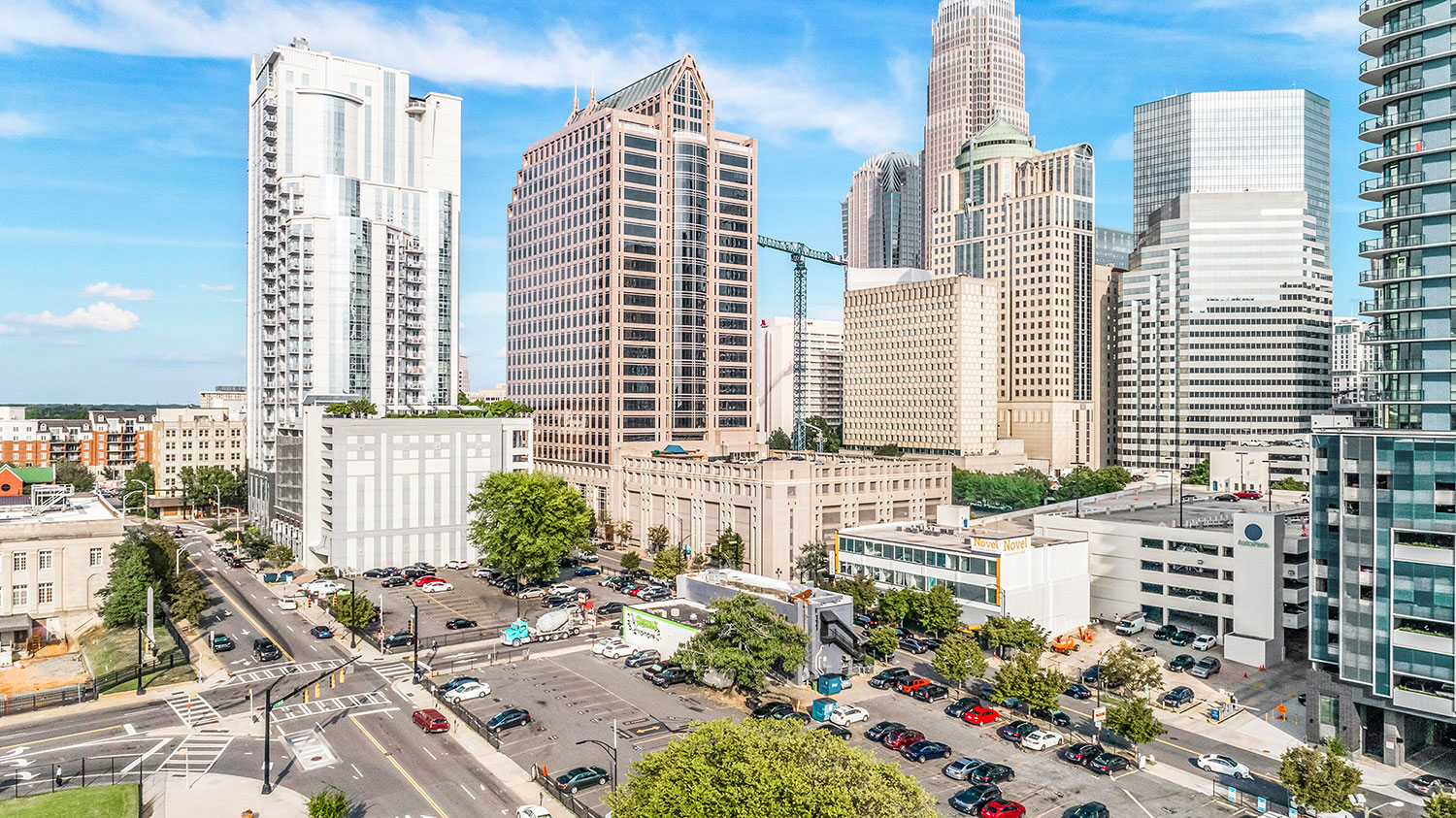
Commercial Development Land |
|
200FT – COMMERCIAL DEVELOPMENT LAND SITE
|
|
Commercial development land supports future retail, office, hospitality, and mixed use projects. These parcels are often valued for visibility, access, zoning flexibility, and proximity to population centers, employment hubs, and established commercial corridors.
|
|
GROUND – COMMERCIAL LAND ROAD FRONTAGE
|
High Visibility ParcelsExterior imagery highlights frontage, curb cuts, signalized access, and surrounding retail or office uses. These elements are essential for evaluating traffic exposure and development potential.
|
|
Commercial land is frequently located along arterial roads, near interchanges, or within expanding trade areas. Aerial perspectives help document parcel shape, access points, and adjacency to complementary commercial development.
|
|
ROOF – ADJACENT COMMERCIAL DEVELOPMENT
|
400FT – COMMERCIAL CORRIDOR OVERVIEW
|
|
For developers and investors, consistent documentation of commercial land supports site selection, underwriting, and entitlement discussions. Aerial imagery also assists with communicating visibility, scale, and surrounding market dynamics.
|
|
TWILIGHT – COMMERCIAL PAD SITE
|
100FT – RETAIL DEVELOPMENT PARCEL
|
GROUND – OFFICE DEVELOPMENT LAND
|
200FT – COMMERCIAL INFILL PARCEL
|
| Commercial Pad Site | Retail Development Land | Office Development Parcel | Commercial Infill Land |
|
Additional Commercial Development Land we have photographed: Besides retail pad sites, office development parcels, and mixed use commercial tracts, we have also captured: highway frontage commercial land, entitled commercial acreage, infill redevelopment parcels and many other commercial land properties across the US. Need one photographed? Order Now >>
|
Residential Development Land |
|
100FT – RESIDENTIAL DEVELOPMENT LAND SITE
|
|
Residential development land supports future single family, multifamily, and master planned housing projects. These parcels are evaluated based on access, zoning, density allowances, utilities, school districts, and proximity to employment centers and amenities.
|
|
GROUND – SUBDIVISION LAND FRONTAGE
|
Future Housing SitesExterior imagery highlights parcel boundaries, access points, topography, and relationships to surrounding neighborhoods. These details help communicate development potential and market context.
|
|
Residential land is often positioned near growing population centers and expanding infrastructure. Aerial perspectives help document terrain, natural features, and adjacency to existing residential development.
|
|
200FT – MULTIFAMILY DEVELOPMENT LAND
|
ROOF – ADJACENT RESIDENTIAL COMMUNITY
|
|
For developers and land investors, consistent documentation of residential land supports entitlement efforts, density analysis, and marketing to builders or institutional capital partners.
|
|
TWILIGHT – MASTER PLANNED COMMUNITY LAND
|
400FT – RESIDENTIAL DEVELOPMENT TRACT
|
GROUND – SINGLE FAMILY LAND PARCEL
|
200FT – INFILL RESIDENTIAL LAND
|
| Master Planned Land | Residential Tract | Single Family Parcel | Infill Residential Land |
|
Additional Residential Development Land we have photographed: Besides subdivision parcels, multifamily development sites, and master planned residential tracts, we have also captured: single family development land, entitled residential acreage, infill housing parcels and many other residential land properties across the US. Need one photographed? Order Now >>
|
Mixed Use and Master Planned Land |
|
400FT – MIXED USE MASTER PLANNED LAND SITE
|
|
Mixed use and master planned land supports large scale, multi phase development that integrates residential, commercial, hospitality, and sometimes industrial components. These sites are typically guided by long range planning frameworks and municipal coordination.
|
|
GROUND – MASTER PLANNED COMMUNITY FRONTAGE
|
Multi Phase Development SitesExterior imagery highlights land scale, internal road networks, phase boundaries, and relationships to surrounding infrastructure. These elements are critical for communicating long term development vision.
|
|
Master planned land often includes designated areas for residential neighborhoods, retail districts, office campuses, and open space. Aerial perspectives help document layout, connectivity, and future build out potential.
|
|
200FT – MIXED USE LAND OVERVIEW
|
ROOF – ADJACENT COMMERCIAL AND RESIDENTIAL USES
|
|
For developers, municipalities, and investors, consistent documentation of mixed use land supports entitlement approvals, public presentations, and capital formation efforts across extended development timelines.
|
|
TWILIGHT – MIXED USE LAND FRONTAGE
|
100FT – MASTER PLANNED LAND PARCEL
|
GROUND – MIXED USE DEVELOPMENT LAND
|
400FT – MASTER PLANNED COMMUNITY SITE
|
| Mixed Use Frontage | Master Planned Parcel | Development Land | Planned Community Site |
|
Additional Mixed Use and Master Planned Land we have photographed: Besides large scale mixed use tracts, master planned community land, and phased development sites, we have also captured: entitled mixed use acreage, long term master planned parcels, multi phase development land and many other mixed use land properties across the US. Need one photographed? Order Now >>
|
Highway Frontage and Infill Land |
|
200FT – HIGHWAY FRONTAGE LAND SITE
|
|
Highway frontage and infill land parcels are valued for visibility, access, and redevelopment potential within established corridors. These sites often serve retail, service, industrial, or mixed use development that benefits from daily traffic exposure.
|
|
GROUND – INTERSTATE ACCESS FRONTAGE
|
Visibility Driven SitesExterior imagery highlights frontage length, curb cuts, ramps, and proximity to interchanges. These details help communicate traffic exposure and ease of access for future users.
|
|
Infill parcels within developed areas often present redevelopment opportunities with existing utilities and surrounding demand. Aerial perspectives help document parcel constraints, neighboring uses, and circulation patterns.
|
|
ROOF – ADJACENT COMMERCIAL CORRIDOR
|
400FT – URBAN INFILL LAND OVERVIEW
|
|
For investors and developers, consistent documentation of frontage and infill land supports site selection, feasibility analysis, and marketing to end users. Aerial imagery also assists with illustrating visibility and access advantages.
|
|
TWILIGHT – HIGHWAY FRONTAGE PARCEL
|
100FT – INFILL COMMERCIAL LAND
|
GROUND – URBAN REDEVELOPMENT SITE
|
200FT – ARTERIAL ROAD FRONTAGE
|
| Highway Frontage | Infill Parcel | Redevelopment Site | Arterial Frontage |
|
Additional Highway Frontage and Infill Land we have photographed: Besides interstate frontage parcels, urban infill sites, and arterial road tracts, we have also captured: signalized corner parcels, redevelopment land sites, high visibility commercial frontage and many other frontage and infill land properties across the US. Need one photographed? Order Now >>
|
Undeveloped and Entitled Land |
|
400FT – ENTITLED DEVELOPMENT LAND SITE
|
|
Undeveloped and entitled land represents properties at different stages of the development lifecycle, ranging from raw acreage to parcels with approved zoning, site plans, or development entitlements. Value is closely tied to regulatory status, access to utilities, and readiness for construction.
|
|
GROUND – ENTITLED LAND ROAD ACCESS
|
Development Ready SitesExterior imagery highlights access points, parcel configuration, utility proximity, and surrounding development. These elements help communicate construction readiness and regulatory progress.
|
|
Entitled land is often positioned to move quickly into development once market conditions align. Aerial perspectives help document boundaries, grading, and infrastructure that support accelerated timelines.
|
|
200FT – UNDEVELOPED LAND OVERVIEW
|
ROOF – ADJACENT INFRASTRUCTURE
|
|
For developers and investors, consistent documentation of undeveloped and entitled land supports underwriting, entitlement marketing, and capital sourcing. Aerial imagery also assists with illustrating development readiness and risk mitigation.
|
|
TWILIGHT – ENTITLED LAND FRONTAGE
|
100FT – SHOVEL READY PARCEL
|
GROUND – RAW LAND SITE
|
400FT – ENTITLED ACREAGE
|
| Entitled Frontage | Shovel Ready Parcel | Raw Land | Entitled Acreage |
|
Additional Undeveloped and Entitled Land we have photographed: Besides shovel ready sites, entitled development parcels, and raw acreage, we have also captured: approved subdivision land, zoned commercial parcels, development ready tracts and many other undeveloped and entitled land properties across the US. Need one photographed? Order Now >>
|
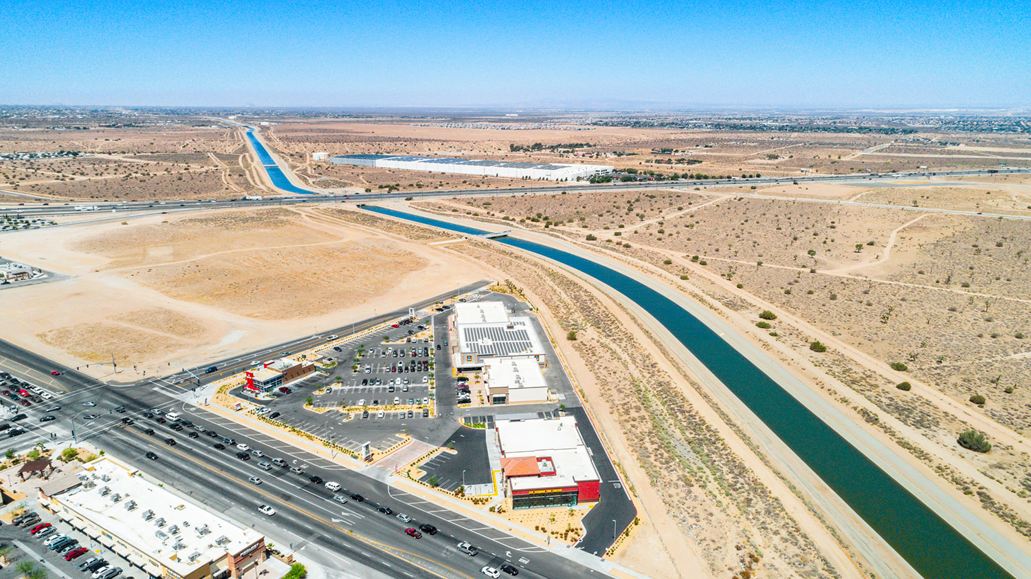
Large Acreage and Investment Land |
|
400FT – LARGE ACREAGE INVESTMENT LAND
|
|
Large acreage and investment land is typically acquired for long term appreciation, assemblage potential, or future rezoning opportunities. These properties emphasize scale, location trajectory, access to infrastructure, and surrounding growth patterns rather than immediate development.
|
|
GROUND – RURAL LAND ACCESS ROAD
|
Long Term Hold SitesExterior imagery highlights access points, boundary clarity, and relationships to nearby development or infrastructure. These details help communicate investment context and future optionality.
|
|
Investment land is often positioned on the path of growth or near expanding transportation corridors. Aerial perspectives help document scale, topography, and adjacency that influence long term value.
|
|
200FT – LARGE TRACT LAND OVERVIEW
|
ROOF – ADJACENT LAND USE CONTEXT
|
|
For land investors and institutional owners, consistent documentation of large acreage holdings supports portfolio reporting, valuation analysis, and strategic planning over extended hold periods.
|
|
TWILIGHT – RURAL INVESTMENT LAND
|
100FT – AGRICULTURAL INVESTMENT ACREAGE
|
GROUND – LARGE PARCEL FRONTAGE
|
400FT – EXPANSIVE LAND HOLDING
|
| Rural Investment Land | Agricultural Acreage | Parcel Frontage | Land Holding |
|
Additional Large Acreage and Investment Land we have photographed: Besides rural investment tracts, agricultural holdings, and long term land positions, we have also captured: assemblage parcels, future development acreage, strategically located land investments and many other large acreage properties across the US. Need one photographed? Order Now >>
|
Solar, Green & Utility Land |
|
400FT – SOLAR ENERGY/Solar panels LAND SITE
|
|
Specialty and utility land supports non traditional uses that require specific location characteristics, zoning allowances, and infrastructure access. These properties often serve energy production, data infrastructure, waste management, conservation, or public utility functions.
|
|
GROUND – UTILITY ACCESS AND INFRASTRUCTURE
|
Purpose Built SitesExterior imagery highlights land scale, infrastructure corridors, buffer zones, and adjacency to compatible uses. These elements are critical for evaluating feasibility and regulatory compliance.
|
|
Utility and specialty land parcels are often driven by access to power, water, transportation, or natural resources. Aerial perspectives help document site configuration, setbacks, and relationships to surrounding land uses.
|
|
200FT – DATA CENTER DEVELOPMENT LAND
|
ROOF – ADJACENT UTILITY CORRIDORS
|
|
For landowners, operators, and institutional investors, consistent documentation of specialty land supports permitting, environmental review, and long term asset planning across highly regulated use cases.
|
|
TWILIGHT – SOLAR FARM SITE
|
100FT – WIND ENERGY LAND
|
GROUND – CONSERVATION LAND PARCEL
|
400FT – UTILITY LAND HOLDING
|
| Solar Energy Land | Wind Energy Site | Conservation Land | Utility Land |
|
Additional Specialty and Utility Land we have photographed: Besides solar farm sites, data center land, and utility corridors, we have also captured: wind energy parcels, conservation land tracts, infrastructure related land sites and many other specialty land properties across the US. Need one photographed? Order Now >>
|
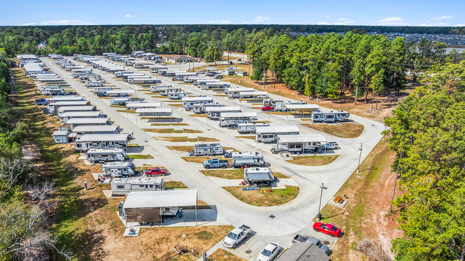
Campgrounds and RV Parks |
|
400FT – CAMPGROUND AND RV PARK SITE
|
|
Campgrounds and RV parks are specialized land assets that combine recreational use with income producing infrastructure. These properties range from primitive campgrounds to fully improved RV resorts featuring utilities, internal road networks, and amenity areas designed for short and long term stays.
|
|
GROUND – RV PAD AND ROAD ACCESS
|
Recreation Oriented Land AssetsExterior imagery highlights pad layout, internal circulation, utility hookups, and amenity placement. These details help communicate operational functionality and guest experience.
|
|
From a land perspective, campgrounds and RV parks are defined by acreage, site organization, topography, and proximity to highways or destination attractions. Aerial imagery clearly documents scale, environmental features, and circulation patterns.
|
|
200FT – CAMPGROUND LOOP OVERVIEW
|
ROOF – AMENITIES AND COMMON AREAS
|
|
For owners and investors, consistent documentation of campground and RV park properties supports marketing, operational planning, and long term land valuation.
|
|
TWILIGHT – RV PARK ENTRANCE
|
100FT – CAMPSITE ROWS
|
GROUND – COMMUNITY FACILITIES
|
200FT – RV RESORT OVERVIEW
|
| RV Park Entrance | Campsites | Facilities | Resort Overview |
|
Additional Campgrounds and RV Parks we have photographed: Besides seasonal campgrounds and full service RV resorts, we have also captured: destination campgrounds, hybrid RV and cabin parks, recreational vehicle communities and many other campground properties across the US. Need one photographed? Order Now >>
|
Playgrounds and Outdoor Play Structures |
|
200FT – PLAYGROUND SITE OVERVIEW
|
|
Playgrounds and outdoor play structure sites are purpose built land assets serving public, municipal, school, and private recreational uses. These properties support community engagement and are often integrated into parks, residential developments, and mixed use environments.
|
|
GROUND – PLAY STRUCTURE ENTRANCE
|
Community Recreation SitesExterior imagery highlights equipment layout, safety surfacing, fencing, shade structures, and pedestrian access. These details support planning, documentation, and public communication needs.
|
|
Outdoor play sites are defined by layout, accessibility, and integration with surrounding land uses. Aerial perspectives clearly document boundaries, circulation, and proximity to adjacent facilities.
|
|
400FT – PARK AND PLAYGROUND CONTEXT
|
ROOF – EQUIPMENT LAYOUT VIEW
|
|
For municipalities, school districts, and developers, consistent aerial documentation supports planning approvals, maintenance records, and community outreach initiatives.
|
|
TWILIGHT – COMMUNITY PLAYGROUND
|
100FT – PLAY EQUIPMENT ZONES
|
GROUND – ACCESSIBLE PLAY AREAS
|
200FT – PARK SITE OVERVIEW
|
| Community Playground | Equipment Zones | Accessible Areas | Park Overview |
|
Additional Playgrounds and Outdoor Play Structures we have photographed: Besides municipal playgrounds and school play areas, we have also captured: destination playgrounds, inclusive play structures, community park installations and many other recreational sites across the US. Need one photographed? Order Now >>
|
Commercial Real Estate Photography Samples |
||
|
We provide professional aerial and ground photography across all major commercial real estate asset types. Explore additional categories below to view real examples of our work capturing retail, office, industrial, land, residential, and hospitality properties nationwide.
|
||
|
|
|

|
|

|
|
|
|
Land Commercial Real Estate Photography