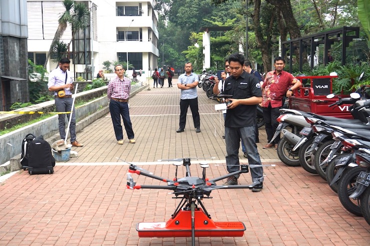
Terra Drones Designs Drone With Ground Penetrating Radar to Map Underground Pipes, Tunnels and Wiring

© Terra Drone
In 2016, Toru Tokushige established Terra Drone in Tokyo, Japan with the goal of becoming one of the world’s leading industrial drone providers. In just a few short years, Toru has seen his dreams come true as Terra now has locations and customers all over the world. “We have created the world’s first universal drone solutions platform with an aim to facilitate the growth of the drone industry as a whole,” Toru said. “We, at Terra Drone, are able to provide the most advanced and comprehensive gamut of drone-based offerings all over the world by collaborating with those partners and technology providers who are already known to be pioneering unmanned aerial solutions and services in their respective countries or regions.” The Indonesia offices, headquartered in Jakarta, recently announced a new project that will revolutionize drone mapping services.
Terra Drone Indonesia provides drone services primarily for construction, mining, oil and gas, energy, and utility industries. In a partnership with PT Airborne Geophysics Indonesia (AGI) and the Geophysics Laboratory at the Bandung Institute of Technology (ITB), Terra has begun testing new drone software that maps below the ground while still airborne. As described on their website, “AGI is a Geophysical service company established in 2017 by some Indonesian professionals with a background of expertise that aligned and specialized their expertise in earth sciences.” ITB is ranked as one of the top global universities and is considered to have one of the most advanced and selective science and engineering programs worldwide. Together they have completed the pilot program for a drone with a Ground Penetrating Radar (GPR) system.
Using drones for mapping is not a new concept, drones are ideal mapping tools. They can collect multiple levels of visual data to be compiled into detailed maps simply by flying over a targeted area. For mapping below ground structures like tunnels and pipe systems, drones can be lowered into the structure and controlled through the space to gather the data. Terra’s GPR system is able to create these maps without having to send a drone below ground, providing surveyors an accurate and safe means of data collection. As explained on Terra Indonesia’s website, “Drone GPR are lightweight (compared to a manned airplane or a helicopter), easily transportable by car and capable of flying autonomously at low altitudes with high precision. Such an approach assures delivery of accurate survey results, is also safer for personnel and more time-efficient. A GPR mounted on a drone enables to see through the surface of ground, ice, rocks, freshwater, and buildings or through structures at unsafe and hazardous environments without compromising the safety of staff, providing an additional solution for more efficient surveying.”
In the trial program, Terra flew the drone over the ITB campus at different altitudes and speeds to map a network of below ground tunnels and utilities. After data was collected with the GPR system, it was analyzed by AGI and compared to the university’s original infrastructure records. AGI asserted that the drone and the GPR system created an accurate map of the structures below ITB. Michael Wishnu Wardana, Managing Director of Terra Drone Indonesia said, “The conventional GPR method requires field personnel to go to the field and carry GPR tools to conduct surveys. But this method has its own dangers because not only are some areas unsafe and difficult to reach but also because severe weather conditions in the field can hamper workers from carrying out their jobs diligently. GPR drones, in contrast, have emerged as a much safer and efficient surveying solution.”
Terra’s GPR drone system opens up the possibilities for many applications. The system can be used to survey a construction site for buried wires, lines, or tunnels. It can be used to inspect pipes for wear and tear. It can be used to map post blast mining zones for safe entry. All of these services, and more, can be done precisely and quickly without putting any people at risk in these dangerous environments. As Toru Tokushige said, “We are committed to being the #1 industrial drone solutions provider in the world. To that end, we must continuously invent, design, and develop breakthrough drone hardware, software, solutions, and services.” Terra’s new GPR drone system is indeed a breakthrough in drone capabilities.
|