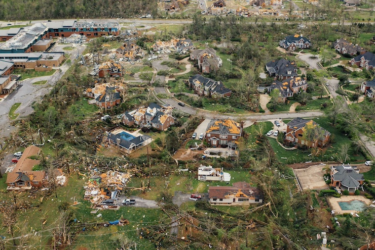
Drones Increasing Their Role in Post-Disaster Assessments

Drone hobbyists are playing an increasingly visible role as informal news gatherers in the aftermath of extreme weather events. During two recent tornado disasters, including last week’s near Tallahassee Florida, private drone fliers launched their UAVs to provide an aerial view of the devastation to homes and property that lay in the storms’ wake.
Unlike local news stations, which are often dependent on helicopters that are expensive to pilot and fly and must be formally commissioned for service during office hours, observing struct station protocols, drone hobbyists can launch their aircraft at will. And they can have their video footage posted on YouTube within hours or even minutes of the disaster, “scooping” even the most venturous official news outlets.
Increasingly, drone hobbyists are selling their raw unedited footage to local and even national TV broadcasters, which then circulate it widely across the Internet. In this fashion, drone hobbyists are now actively shaping the public’s perception of major weather events, becoming important adjuncts to official news reporting.
Drone surveillance of a more official nature is also playing an important role in post-disaster relief and recovery operations. In this case, it is usually public safety organizations and emergency responders that are deploying their own drones, and conducting in-depth aerial surveys to locate potential survivors in need of rescue and to provide tactical intelligence to ground-based rescue crews. Alternatively, private professional drone companies might be contracted by state or local governments to conduct the same work, and might also be retained by insurers to provide authoritative liability estimates.
In some cases, drone companies or individuals have flown overflights missions on behalf of local homeowners seeking to understand how badly their housing was affected and the safety risk that might be involved in returning to inspect or re-occupy their premises.
Intergovernmental agencies like the World Health Organization are also increasingly interested in deploying drones for post-disaster relief and recovery purposes. In fact, these assessments are also being used to identify weather and other environmental and structural conditions (e.g. weak levees or flood plains) that helped precipitate the disaster, with an eye toward mitigating them.
For example, improved tornado watch warnings can allow local residents in disaster-prone areas to better prepare for major weather events through early evacuation as well as through advance prepositioning of emergency shelters and relief supplies.
Some disaster-prone states are following suit. In Mississippi, an innovative partnership between Mississippi State University and FEMA has resulted in the prepositioning of drone fleets that are also available for search-and-rescue operations as well as post-disaster damage assessments.
However they’re deployed – through individuals operating on their own or through private or public agencies operating separately or in tandem – drones are proving themselves to be vital tools for documenting the evolving pattern of extreme weather events facing the globe, especially as the effects of global warming become more apparent.
Thanks to drone surveillance, citizens are becoming better informed and better prepared – allowing more lives to be saved, future events to be mitigated, and a semblance of normal life restored more quickly.
|