Using Drones to Discover Ancient Worlds

© Michael Frachetti, Professor of Archaeology at Washington University in St. Louis, MO
Director Steven Spielberg’s 1981 film Raiders of the Lost Ark, starring Harrison Ford as a whip-wielding, globe-trotting, dashing archaeologist, was an instant success. It cost $20 million to make but brought in approximately $354 million in its release year. The film spawned four sequels, a television series, comics, games, and more. People worldwide became enamored with the adventures that a seemingly mundane profession such as archaeology could present. It’s safe to assume that the Indiana Jones franchise influenced quite a few people to enter the field of archaeology.
But is archaeology truly as adventurous as portrayed in Spielberg’s films? Probably not, but that also depends on what you find adventurous. Archaeology is a multidisciplinary field that provides insight into how civilizations became what they are today. It serves as a blueprint for modern society, offering a way to understand the roots of who we all are. When the British archaeologist and Egyptologist Howard Carter discovered Tutankhamun’s tomb in 1922, he didn’t face an adventure like Indiana Jones, but it was still an adventure. After years of steady research, he and his team spent months meticulously digging to uncover a treasure trove of ancient artifacts. This discovery made the study of archaeology a household name and even influenced the character of Indiana Jones.
Today, archaeologists have the power of technology to enhance their explorations far beyond the pickaxe, shovel, and trowel used by adventurers like Howard Carter. On October 23, 2024, Michael Frachetti, Professor of Archaeology at Washington University in St. Louis, MO, published a paper in the journal Nature about how he used drones to uncover an archaeological wonder. Titled “Large-scale Medieval Urbanism Traced by UAV–LiDAR in Highland Central Asia,” the paper explains how drones played a pivotal role in the discovery of two recently located sections of the ancient Silk Road.
The Silk Road was a network of trade routes throughout Eurasia that was active from 202 BCE through the mid-15th century. These expansive trade routes covered more than 4,000 miles and helped establish the cultural, religious, and economic landscape of the Eastern and Western worlds. Professor Frachetti used drones equipped with LiDAR to scan areas of southeastern Uzbekistan in Tashbulak and Tugunbulak. The region, as Professor Frachetti explains in his paper, is very mountainous and covered with centuries of vegetation and development, making it particularly difficult to access in a timely manner for archaeological surveys.
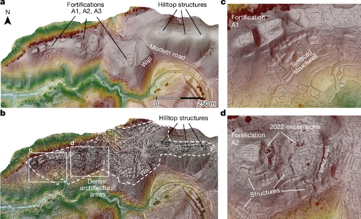
However, with the advancement of drone technology, Professor Frachetti was able to use LiDAR to obtain detailed images of what lay beneath the ground in record time. He conducted a total of 22 drone flights to scan an area that would have previously taken him a decade to complete. “Although hidden by centuries of surface processes, our pairing of very high-resolution surface modeling with semiautomated feature detection produces a detailed plan of monumental fortifications and architecture spanning 120 ha at Tugunbulak, thereby demonstrating one of the largest highland urban constellations in premodern Central Asia,” the paper states. “Documentation of extensive urban infrastructure and technological production among medieval communities in Central Asia’s mountains—a crucial nexus for Silk Road trade networks—provides a new perspective on the participation of highland populations in the economic, political and social formation of medieval Eurasia.”
Professor Frachetti’s adventure in Uzbekistan brings to light a new way of exploring the ancient world through modern advancements. “The final high-res maps were a composite of more than 17 drone flights over three weeks. These are some of the highest-resolution LiDAR images of archaeological sites ever published,” Professor Frachetti said. “We were quite surprised when the image was compiled, as the high resolution reveals so much about the structure of the cities with such clarity.” He went on to say that by using drone technology, “We could really change the map of urban development in medieval Asia.” Professor Frachetti didn’t have to face the dangers that the fictional Indiana Jones encountered; however, he likely felt a similar sense of awe and excitement when compiling the drone data, akin to Indiana’s feelings upon discovering the Lost Ark. The combination of drones, LiDAR, and new discoveries may sound like something out of a Spielberg film, but in reality, it is part of the everyday adventures of a modern archaeologist.
|