
BurnBot Uses Drones to Stop Wildfires Before They Start
© BurnBot.com
In a 2024 issue of the peer-reviewed scientific journal Nature Ecology and Evolution, Dr. Calum Cunningham, a Postdoctoral Research Fellow at the University of Tasmania in Hobart, revealed his findings on increasing global wildfire trends. Dr. Cunningham and his team studied satellite images of wildfires from January 1, 2003, through November 30, 2023. The results of the study showed a 2.2-fold increase in wildfire events and a 2.3-fold increase in the intensity of these events.
“The impact of these extreme events is devastating, not only for natural ecosystems but also for human populations. These fires release significant carbon emissions, threatening to create a vicious cycle that further accelerates global warming,” Dr. Cunningham said. As climate change continues to influence wildfires, some measures can be taken to prevent and mitigate such disasters. With advancements in technology, drones have become useful tools for fire prevention and safety.
Some companies now offer drone services to assess properties for possible fire hazards. Using drones to map a property provides homeowners with a comprehensive view of vegetation that should be cleared, as well as roof and structural areas that may be prone to fire damage. Other companies are using drones in prescribed or controlled burns. This method involves purposely setting fires in a controlled manner to prevent larger wildfires. Controlled burns minimize flammable vegetation and leave trenches that act as fire barriers if a wildfire does occur. This is precisely what BurnBot has been doing since 2020.
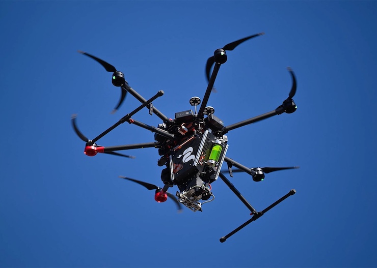
In response to the devastating wildfires sweeping through their native California, Dr. Anukool Lakhina and Dr. Waleed Haddad founded BurnBot out of San Francisco. Combining their expertise in computer science and physics, Dr. Lakhina and Dr. Haddad utilize a series of drone instruments to safely and efficiently prevent wildfires. The first step in a BurnBot operation is to assess the land using a drone equipped with thermal cameras to create a treatment map. This map shows the BurnBot team the exact areas of vegetation to either cut back or burn. It also provides predictive data on how a wildfire may travel based on the landscape and weather conditions.
Once the drone map is complete, BurnBot deploys either aerial or ground drones to treat the area. For aerial missions, BurnBot uses the Ignis UAS system developed by Drone Amplified, based in Lincoln, Nebraska. The drone can carry up to 450 spheres called Dragon Eggs that ignite when they are shot from the drone and make contact with the ground. Using the drone allows BurnBot to access hard-to-reach areas prone to excessive vegetation growth. “A safer and cost effective way to conduct prescribed fire and wildfire ignition operations,” BurnBot states on their website, “the Ignis UAS system can safely burn up to 2,000 acres a day. BurnBot’s drone technicians can safely execute both small- and large scale firing operations with precision, efficiency, and higher safety margins than traditional helicopter PSD missions.”
Additionally, BurnBot uses two types of ground drones to prevent wildfires. The first is a lightweight, remotely operated masticator that chews up and mulches vegetation. This ground drone can handle steep, rocky terrain, has a 61-inch cutting head, and a 500-foot operating range. The second ground drone, called RX, is a vehicle designed to make precise prescribed burns in a contained environment. It slowly drags an open-bottomed container with a 22-inch ground clearance along the prescribed route. Inside the container is an array of torches that can be precisely controlled. The container’s low profile and a fan system on its top minimize embers and excessive smoke, allowing for a clean, controlled burn, all remotely operated. Finally, a series of water nozzles and a heavy roller at the back of the drone extinguish any traces of the prescribed burn.
Since its inception, BurnBot has worked with fire and land management teams throughout California, Oregon, Washington, Nevada, and Idaho. It is a fire prevention method that Dr. Lakhina says, with constant maintenance, can make all the difference for wildfire-prone regions. “The scale of the problem requires new technology requires robots to do the work because there simply aren’t enough people,” he said. “And then vegetation has this bad habit of growing right back up again, so you have to continuously do it.” As wildfires continue to escalate in scale and intensity, innovative solutions driven by drone technology offer hope for fire prevention and control that protect both people and the planet.
|