
Meta Collaborates with Saildrone for Deep Sea Data Collection
© Saildrone.com
When most people think of Mark Zuckerberg, the first thing that comes to mind is Facebook and its accompanying social media apps, Instagram and WhatsApp. These platforms have revolutionized how billions of people around the world communicate. On October 28, 2021, Zuckerberg officially changed the company’s name from Facebook to Meta Platforms to reflect a growing desire to evolve beyond social media and embrace an advanced technology ecosystem. One of the company’s first groundbreaking technology projects, however, took place before its rebranding, beginning in 2014.
From 2014 to 2018, Facebook’s Connectivity Lab launched the Aquila Project, aimed at providing internet access to remote regions. Designed and built by Ascenta in their Bridgewater, England factory, Aquila was a large V-shaped, solar-powered drone intended to function as an atmospheric satellite. The drone had a wingspan of 140 feet, roughly the size of a Boeing 737, but weighed only 880 pounds. It could fly as high as 90,000 feet during the day and descend to 60,000 feet at night. Aquila was designed to remain airborne for up to three months at a time, providing internet services to an estimated four billion users in Africa.
Aquila made its maiden flight on June 28, 2016, in Arizona, followed by several test flights. However, with advancements in other unmanned aerial systems capable of similar functions, the project was abandoned in 2018. Moving forward, Meta has shifted its focus to another form of drone technology, this time with nautical drones. On June 3, 2025, Saildrone published a press release announcing their partnership with Meta and the completion of a first-of-its-kind deep water cable survey using an ocean surface drone.
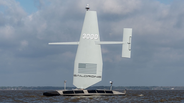
Founded in 2012 by Richard Jenkins and based in Alameda, California, Saildrone Inc. has designed a fleet of rugged nautical surface drones used for security and marine exploration. “Saildrone’s products are powered by the most advanced unmanned surface vehicles, delivering observations and insights about activities above and below the ocean’s surface,” the company website states. “Utilizing renewable wind and solar energy, these vehicles maintain a low operational carbon footprint while continuously feeding data in near real time, 24/7/365, to support more informed decision-making.”
For the collaboration with Meta, Saildrone deployed the largest drone in its fleet, the wind-powered Surveyor. It measures 65 feet long and weighs over 17,000 pounds, much of which is due to the Kongsberg EM304 MKII multibeam echo sounder it carries. Along with a suite of other sensors, the Surveyor collects data to create bathymetric maps of the ocean floor. It operates fully autonomously but can be rerouted remotely if observers identify areas needing further inspection.
During the mission with Meta, the Saildrone Surveyor spent 26 days gathering data from the surface of the North Atlantic Ocean, inspecting the Anjana and Aurora subsea cable routes. Over the course of the mission, the drone covered nearly 2,800 miles of seabed at depths exceeding 18,000 feet. The data collected was compared to previous crewed surveys. “This mission demonstrated that autonomous ocean mapping is not just possible, it’s here, and it’s incredibly effective,” said Andy Palmer-Felgate, subsea cable engineer at Meta. “Saildrone delivered data that matched legacy surveys with exceptional accuracy, all while operating remotely and with minimal environmental impact.
Not only was the mission a success, but according to Saildrone, it significantly reduced Health, Safety, and Environmental (HSE) risks by allowing team members to work remotely. In environmental terms, the 26-day survey avoided approximately 243 tons of CO₂ emissions, underscoring the substantial sustainability benefits of replacing conventional manned vessels with autonomous alternatives. For Meta, this project perfectly aligns with their broader future goals.
Meta is currently focusing strategically on building the physical infrastructure to support its global connectivity ambitions. By using autonomous vessels to map safe and efficient routes for undersea cables, Meta aims to expand internet access to remote regions, reduce the high costs and risks of traditional crewed surveys, and support its growing network of data centers. This innovative approach not only lowers operational expenses and environmental impact but also strengthens Meta’s position as a leader in advanced technology and digital infrastructure, essential for delivering the fast, reliable connections needed for future applications like the metaverse.
|