
Founded in 1934, the University of São Paulo (USP) is consistently ranked among the top institutions of higher learning in Latin America. This public state university operates 11 campuses across Brazil, including four in São Paulo, the country’s largest city. USP is especially known for producing the highest volume of scientific research in Brazil, with particular strengths in engineering, environmental and climate sciences, computer science, and artificial intelligence.
Located on the São Carlos campus is the Carlos Engineering School (EESC-USP), the university’s leading science and engineering hub. In June 2025, representatives from EESC-USP presented a novel drone system at FAPESP Week Toulouse, an event organized by the São Paulo Research Foundation (FAPESP), Brazil’s foremost scientific funding agency. This year’s event, held in collaboration with French institutions, focused on innovations in health, biotechnology, aeronautics, and aerospace engineering.
Glauco Augusto de Paula Caurin, a professor of aeronautical engineering at EESC-USP, presented the drone project. Professor Caurin has published several notable papers on the development of drone platforms. Some of his previously published works include Deep Learning for Drone Navigation, Study of Computational Tools for Simulation and Visualization of Drone Applications, and Development of Mechanical Design of Unmanned Aerial Vehicles as Disruptive Transportation Systems.
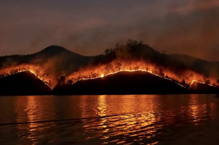
His latest research tackles one of the most urgent environmental challenges today, the rise of extreme wildfires. As global temperatures climb, wildfire frequency and intensity have also increased. In response, Professor Caurin and his team have developed a drone system designed to collect critical data that could help prevent such disasters.
Drone technology already plays a crucial role in wildfire management, including conducting controlled burns, observing fire progression, and more. Professor Caurin’s system integrates low-cost, advanced gas detectors and thermal imaging cameras into a lightweight, autonomous drone platform. The drones scan large areas using thermal sensors to identify abnormal heat signatures that may indicate the early stages of a wildfire.
Simultaneously, gas sensors, specially tuned to detect methane and other greenhouse gases, monitor emissions from landfills, agricultural zones, and industrial sites. The data is transmitted in real-time to ground stations, where machine learning algorithms analyze patterns to distinguish between natural and hazardous sources, enabling faster and more accurate environmental responses.
This system goes beyond simply identifying excess vegetation that could ignite. It captures data that was previously only available via satellite, but now at a more actionable, local scale. “By collecting greenhouse gas data with drones, instead of an average of carbon dioxide or methane on a surface, it’s possible to obtain the volume of distribution of these gases in a given region,” Professor Caurin explained. “Today, even with the best satellites, we’re unable to obtain this volumetric information. With drones, greenhouse gas data collection is no longer a surface map of the region, but rather three-dimensional data.”
Professor Caurin noted that trials have already begun in partnership with Brazil’s Civil Defense, the São Carlos Department of the Environment, and local government representatives. The team has used the drone-based sensors to locate fire hotspots across the municipality of São Carlos. Once identified, mitigation protocols can be activated to help prevent a wildfire from starting. So far, the system has performed well, though there is one significant limitation.
Like most drones, Professor Caurin’s system has a short flight time. A drone’s endurance depends on the ratio of its total weight to battery capacity. As more sensors and components are added, the weight increases, reducing flight time. Currently, the drone can operate for only about 15 to 30 minutes. The next phase of development will focus on improving aerodynamic efficiency to extend its operational range.
While the system currently works best in smaller areas such as urban zones, the long-term goal is to deploy it over larger forest regions. “In the future, with more suitable equipment, we intend to carry out missions in the Amazon,” Professor Caurin remarked. As climate change continues to intensify wildfire risks and greenhouse gas emissions, Professor Caurin’s work represents a vital step toward smarter, more responsive environmental monitoring. By combining advanced sensing technologies with real-time analytics, his drone system offers a scalable and adaptable tool for both prevention and mitigation. With further development and expanded deployment, it holds promise not only for Brazil’s forests and communities, but also as a model for climate resilience efforts around the world.
|