
DJI Drones Are Helping Western States Predict and Control Their Avalanches
Can drones predict the likelihood of snow avalanches — and even help rescue their victims when they occur? Apparently they can.
The Alaska Department of Transportation and Public Facilities (DOT&PF) recently field tested tech giant DJI’s ability to perform avalanche risk assessment missions in the state’s snowy climbs. Alaska DOT&PF has turned to drones in the past, with mixed success. But its most recent tests were conducted with tech giant DJI’s new DJI Dock, which allows drone missions to be pre-programmed on a regular schedule and conducted fully autonomously, without the need for remote piloting and recurring launches. As a result, the agency’s drone avalanche surveillance is about to become more timely, comprehensive and effective, officials say.
DJI had previously tested DJI Dock in Europe and elsewhere, but this was the China-based company’s first test of DJI Dock in the United States. What makes it so unique? The new system uses state of the art “drone in a box“ technology which allows a drone to launch automatically from a docking station and then return to the station to have its batteries recharged before taking off again. In addition, upon completing its flights, the drone automatically returns to the station for self-storage. Thanks to DJI Dock, drones can conduct aerial surveys day and night with limited interruption. The time and cost savings – with reduced human labor and enhanced operational efficiency – are substantial.
While Alaska DOT&PF hasn’t released details on its new aerial survey techniques, recent research studies have detailed the precise methods used and why they are potentially so effective for avalanche risk assessments.
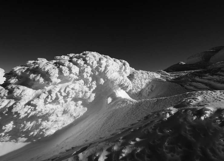
For example, in a study conducted at the University New Hampshire last year, researchers flew repeat aerial drone missions over Mount Washington to record how stiff seasonal winds blowing at speeds of 40 mph or more would rapidly deposit heavy layers of snow over lighter “sugary” layers resulting in unstable “snowpacks” some 20-feet deep. The snowpacks might rest for days or weeks in some of the mountain’s steepest ravines, waiting to be triggered, either by more accumulating snow, changing weather conditions or by the movements of human skiers.
The drone’s specially equipped cameras were able to measure the location, breadth and depth of snow layers precisely and to correlate the rate and level of snow accumulation with the timing of subsequent avalanches, taking due note of additional triggers. In theory, by modeling these same conditions for predictive purposes, it will be possible to identify avalanche-prone snow packs more precisely and to issue warnings of a potential avalanche well in advance of one actually occurring, researchers say.
For now DJI and Alaska DOT&PF appear to be limiting their partnership to avalanche risk assessment and prediction alone. However, other locales and studies have shown that DJI drones equipped with ground-penetrating radar can also be used to locate avalanche victims, hopefully in time to rescue them. For example, a Latvia-based technology firm, SPH Engineering, has pilot-tested a drone-based ground-penetrating radar system in a mountainous region of northern Spain. Local officials typically employ snow nets and other barriers to try to prevent flash avalanches from sweeping across mountain roads burying vehicles and their passengers. Invariably, some larger avalanches overtake those barriers leaving untold victims buried. In Spain, SPH deployed a DJI M600 drone equipped with a GPR system to map the terrain below the avalanche to locate potential victims, relaying the data collected to a ground-based SAR team. Several deceased avalanche victims were identified and their bodies retrieved,
The drone pilot wasn’t perfect. DJI drones failed to rescue avalanche survivors, which is difficult under any circumstances. Most avalanche victims can only survive for 15-20 minutes buried under snow, though somewhat longer if trapped in vehicles. Improving response time is one critical need moving forward. In addition, without sense-and-avoid technology, the low-flying DJI drones needed careful remote piloting to avoid collisions, and the low area temperatures degraded the drone’s GPS and battery functionality.
In its final report SPH concluded that with additional refinements, including the adoption of a Beyond Visual Line of Sight capability, a fully autonomous drone-based GPR system could complement existing avalanche search and recovery methods, possibly locating live victims in time for a successful rescue.
Aerial drones do have one final important avalanche mission: Instead of simply predicting an avalanche, they can also preemptively trigger one. For years, the methods employed to do so were primitive, to say the least. Local officials would shell mountain slopes with artillery fire, leaving behind explosive debris, and on occasion, dangerous unexploded munitions. Using helicopters or ski patrols were one alternative, but these methods were still time consuming and potentially dangerous for the crews and skiers involved.
In 2016, Mountain Drones, a Colorado-based start up, began working with Western ski resorts to test the use of UAVs to drop explosive charges on avalanche-prone mountain slopes after a heavy snowfall. The need is clearly there. For example, in a typical year, the Colorado Department of Transportation conducts more than 1,400 detonations, causing nearly 900 controlled avalanches. However, in 2018, the FAA, averse to explosive-carrying drones as a matter of principle, intervened to prohibit Mountain Drones and its clients from exploring their relationship further. Undeterred, other companies have continued to promote this concept abroad, finding favor in countries with more flexible regulations. Their drones equipped with smaller targeted explosives are proving more effective than traditional methods – and less damaging to the local environment, skiers and tourists.
|