
Drones Help Scientists Track Underwater Volcano That May Soon Erupt
When most people think of volcanoes, images of mountains like Kīlauea Volcano in Hawaii or Mount Kanlaon in the Philippines spewing fiery boulders, plumes of ashy smoke, and rivers of lava come to mind. In reality, the majority of volcanoes are hidden deep below the ocean surface. Submarine volcanoes along mid-ocean ridges make up 75% to 80% of all volcanic activity and are responsible for constantly shaping the marine and terrestrial landscape of Earth.
With millions of underwater volcanoes, of which at least 1,000 are considered potentially active, it is estimated that dozens of these structures erupt annually. However, due to their remote locations, monitoring these events is very difficult. One of the most studied underwater volcanoes is the Axial Seamount, which lies about 300 miles off the coast of Oregon along the Juan de Fuca Ridge in the northeast Pacific Ocean. With advancements in technology, particularly drones, researchers from the University of Washington’s (UW) National Science Foundation’s Ocean Observatories Initiative (OOI) Regional Cabled Array have gained tremendous data on this submarine volcano.
Recently, measurements taken by drones and other equipment have led researchers like UW School of Oceanography Professor William Wilcock to believe that the Axial Seamount is due for a major eruption. “At the moment, there are a couple hundred earthquakes a day, but that’s still a lot less than we saw before the previous eruption,” said Professor Wilcock. “I would say it was going to erupt sometime later this year or early 2026, but it could be tomorrow, because it’s completely unpredictable.”
The volcano spans roughly 500 square miles, lying 4,600 feet below the ocean surface. In recent history, the Axial Seamount erupted in 1998, 2011, and then in 2015. Because of the volcano’s location, relatively little is known about the ecosystem it supports and what happens during an eruption. After the 2011 eruption, the OOI Regional Cabled Array entered its first stage of development. By the 2015 eruption, the array’s more than 140 instruments were able to provide real-time data on the volcano’s activity. Additionally, OOI began deploying the Sentry AUV (Autonomous Underwater Vehicle) to extensively document the volcano long before the array was completed.
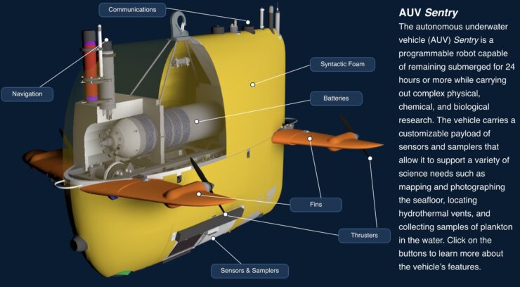
Sentry is an underwater drone developed by the Woods Hole Oceanographic Institution (WHOI) that completed its first scientific mission in 2008. It was specifically designed to autonomously navigate deep ocean terrains without the need for an auxiliary tether. According to WHOI’s Tim Silva, the drone is “capable of reaching a depth of 6,000 meters and carries a wide range of scientific samplers and sensors. Its shape and design also make it highly maneuverable and capable of closely following bottom contours while it uses its multi-beam and sidescan sonars to map the topography. It can also capture thousands of photographs of the seafloor, which can then be stitched together to create an uninterrupted view of seafloor features.”
OOI has been using Sentry to create bathymetric maps of the seafloor surrounding the Axial Seamount. The highly detailed maps created by the drone give researchers an idea of how the volcano influences the marine environment, explained UW Professor of Oceanography and Director of the OOI Regional Cabled Array, Deborah Kelley. “In 2011, we saw one of the venting areas become completely covered in lava flows,” Professor Kelley said. “It wiped everything out. But what’s fascinating is that when we came back three months later, there were animals and bacteria colonizing the area again. They’re surprisingly resilient ecosystems.”
The drone has also been collecting chemical changes in the water from different locations around the seamount. These readings, along with those being collected by the array, closely match data from previous eruptions. In the past, researchers did not have the remote technology to get nearly as much data as they have been able to collect in the last decade. With the combined efforts of the array and drones like Sentry, Professors Wilcock and Kelley say they now have the best view possible of the moments leading up to the pending Axial Seamount eruption, the event itself, and its aftermath.
The research teams plan to continuously live stream the Axial Seamount with sensors on the array and cameras on the drone. For the first time, the public will be able to witness in real time how an underwater volcano explodes and reforms the seafloor. This unprecedented access not only brings cutting-edge science to a broader audience but also deepens our understanding of Earth’s dynamic processes beneath the ocean surface. As technology continues to evolve, so too does our ability to explore, predict, and learn from the powerful forces shaping our planet.
|