
Drones Reveal Ancient Mega-Fortress
© Cranfield University
Drones are tools that are reshaping how people live today and will influence how we live in the future. Interestingly, drones are also providing us with a unique view of the past through novel uses in archaeology. Dr. Nathaniel Erb-Satullo, a Senior Lecturer in Archaeological Science at Cranfield University in England, recently published his findings on how drone technology helped him and his team of research assistants discover a massive fortress that had been hidden for thousands of years.
Where Asia and Europe meet, between the Black and Caspian Seas, lie the Caucasus Mountains. For more than 10,000 years, Georgian nomadic shepherds have called the area home, and it was known as an important section of the ancient Silk Road’s northern arm. Since 2018, Dr. Erb-Satullo has been collaborating with the co-director of the Georgian National Museum, Dimitri Jachvliani, to use modern technology to reveal the ancient hidden stories of Georgia’s Caucasus Mountains. Their journey began with old-fashioned groundwork, manually excavating an area suspected of hiding a fortress.
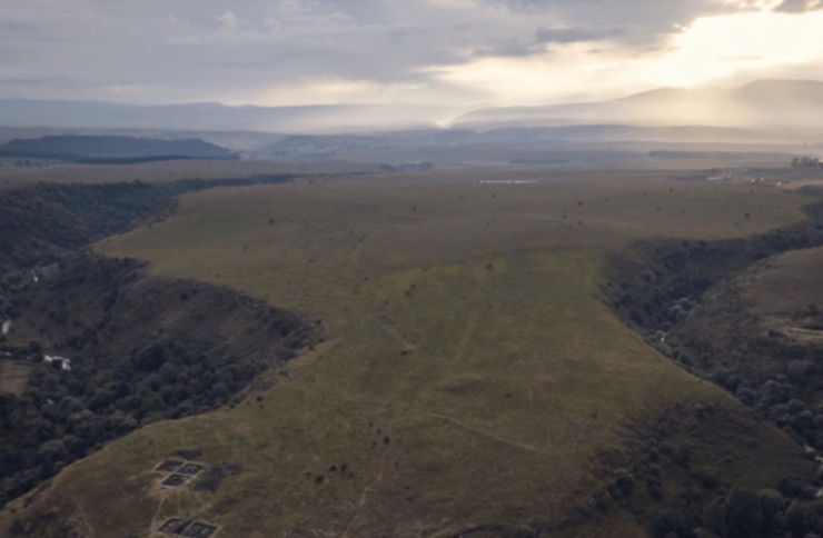
The dig site, named Dmanisi Gora, revealed itself to be far more expansive than Dr. Erb-Satullo and Mr. Jachvliani originally anticipated. Because of the site’s size and the area’s unique landscape, Dr. Erb-Satullo was struck with the idea of using a drone to get a better sense of what they were working with. The archaeologist’s drone of choice was a DJI Phantom 4 RTK, a compact, easy-to-use, and affordable model. “While previous Phantom Series drones were built around professional photographers and hobbyists,” DJI’s website explains, “the Phantom 4 RTK was designed for industrial users for high-precision mapping and other data acquisition missions. While the Phantom 4 RTK shares a similar camera and form size, it also adds a RTK positioning module, a new TimeSync system, a purpose-built mapping app and more.”
The drone has a 30-minute flight time, high-resolution cameras, and sensors for data collection. The RTK (Real-Time Kinetic) positioning module uses GNSS (Global Navigation Satellite Systems) to correct any navigational errors, providing the most accurate geospatial locations within centimeters of precision. Dr. Erb-Satullo and Mr. Jachvliani published their findings on the use of the drone in the Cambridge University journal Antiquity. The paper is titled “Mega-Fortresses in the South Caucasus: New Data from Southern Georgia.” To collect the data, the team flew the drone in autumn, when natural grasses were low enough to avoid interfering with the drone’s sensors.
The data revealed by the drone has changed our understanding of previous settlements in the Caucasus Mountains. “The drone took nearly 11,000 pictures which were knitted together using advanced software to produce high-resolution digital elevation models and orthophotos – composite pictures that show every point as if you were looking straight down,” Dr. Erb-Satullo said. “These datasets enabled us to identify subtle topographic features and create accurate maps of all the fortification walls, graves, field systems, and other stone structures within the outer settlement. The results of this survey showed that the site was more than 40 times larger than originally thought, including a large outer settlement defended by a 1km long fortification wall.”
The drone data displayed that Dmanisi Gora was a fortress-settlement covering roughly 60–80 hectares of land. “High-resolution UAV-based aerial survey of Dmanisi Gora reveals the extent of the large outer fortification system and settlement, which has few documented parallels in the region,” the authors state in the paper’s conclusion. “If the occupation of the inner fortress and outer settlement were roughly contemporary, as we suggest, this settlement would be one of the largest known in the South Caucasus Late Bronze and Iron Age.”
The use of drone technology in archaeology not only enhances our ability to uncover and map ancient sites, but it also opens new doors for discovering the hidden histories of past civilizations. Dr. Erb-Satullo and Mr. Jachvliani’s groundbreaking work in Georgia’s Caucasus Mountains demonstrates the powerful potential of drones to reshape our understanding of ancient settlements, offering a glimpse into a world that has long been buried beneath the earth. As technology continues to evolve, so too will our ability to explore and preserve the past, ensuring that the stories of forgotten civilizations are not lost to time.
|