
Google Along with CyArk Using Drones To Archive Endangered Historical Sites
In 1998, Stanford University Ph.D. students Larry Page and Sergey Brin founded Google to better the way internet search engines operate. Google became one of the fastest growing websites, and within 2 years it was announced that it would be Yahoo!’s default search engine. Today Google is the world’s largest search engine. With internet related services of all kinds, Google has an estimated market cap of over 1 trillion dollars. Google Earth was launched in 2001 and was followed a few years later by Google Maps. Both utilize satellite imagery and aerial photography to create 3D images and maps for navigation. Google Earth and Maps are used by billions of people each month from all over the world. Using the underlying principles that drive Google Earth and Maps, Google Arts & Culture was established in 2011 to create 3D images of art and culture from around the world.
As explained on the official website, “Google Arts & Culture is a non-profit initiative. We work with cultural institutions and artists around the world. Together, our mission is to preserve and bring the world’s art and culture online so it’s accessible to anyone, anywhere.” One of its most recent exhibits is called “Heritage on the Edge”, an exploration of cultural world heritage sites that are in decline. Instead of using just satellite imagery and standard aerial photography, Google used drones to get detailed images of 5 historic sites for preservation. The sites featured are Easter Island’s Moʻai statues, Scotland’s Edinburgh Castle, Tanzania’s Great Mosque of Kilwa Kisiwani, Bangladesh’s Mosque City of Bagerhat, and Peru’s ancient city Chan Chan. Each of these sites is under threat from the damages posed by climate change. With the help of drones and collaboration between Google and CyArk, conservationists can find ways to preserve and restore these historical sites.
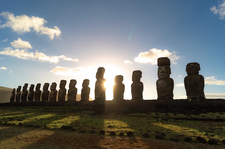
CyArk is a nonprofit organization that promotes the use of digital technology to archive endangered historical sites. As stated by CyArk, “We believe that better data leads to better decision making and is an essential part of the solution for site managers. Accurate baseline documentation provides a stable reference to understand and quantify change, a task essential in understanding the impacts of climate change.” CyArk traveled to sites like Easter Island to train local conservationists on how to use tools like drones. The drones were used to create 3D models of the remaining Moʻai statues built by the Rapa Nui people between the years 1250 and 1500. When the statues were first erected, they were made to withstand time and the elements of the Polynesian Islands. Over the centuries neglect, human interference, and natural land changes began to cause the statues to deteriorate.
All of the sites that CyArk and Google have been documenting have dealt with the same gradual changes. Unfortunately, the climate change of the 21st century is proving to be the demise of these historical landmarks. Rising sea levels, acid rain, pollution, and extreme storms are too much for the ancient structures to bear. Using drones CyArk can quickly document the current status of fragile sites. The drone images are compiled into 3D models. By comparing the drone images taken over a period of time, conservationists can get a clear picture of how rapidly deterioration is happening. The drones aren’t only used to capture images of the structures, but the surrounding area to get an overall picture of all the elements contributing to the problem.
Conservationists look at the images taken by the drones and use them to create plans of action for preventing further damage. On Easter Island the drone images have led to locals locating the exact positions to build a stone wall to protect the Moʻai statues from damaging waves brought on by rising sea levels. Meanwhile, in Edinburgh, drone imagery has shown officials where embankments need to be secured to prevent landslides that threaten the castle. In Tanzania, drone footage led to the planting of mangrove trees around the mosque as a protective barrier to slow down erosion.
All of the images captured by the drones have been made available to the public through the Google Arts & Culture website. The hope is that people all over the world can now observe and appreciate the wonders of these historically important sites before they are lost to the effects of climate change. But more importantly, the exhibit aims to raise awareness as to just how damaging climate change can be. Structures that have stood the test of time are finally succumbing because of global warming. As Francesco Bandarian, former Director to the UNESCO World Heritage Center said “Preserving our endangered cultural heritage should not be seen as a challenge for specialists alone, it is a collective responsibility that reflects core values of contemporary societies, reflected by the mobilization of financial and technical resources, by the development of heritage conservation policies and the support provided to heritage in danger by governments, private organizations, NGOs, and by the public.” By combining the work of inexpensive drones and the global outreach of Google, the plight of in danger heritage sites can not only be protected and restored but brought into the public eye for greater support.
|