
India Adopting Drones to Measure Pollutants and Air Quality
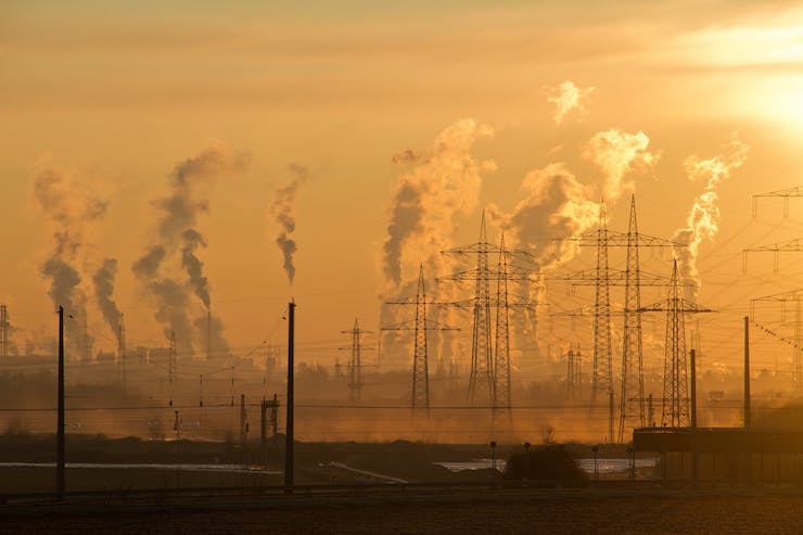
Air pollution is a factor of life that most people living in or around cities have to deal with. This poor air quality can have many long and short term effects on people. It can cause nausea, headaches, dizziness, respiratory diseases, heart disease, and lung cancer. Often people don’t realize they are suffering from air pollution symptoms because it is an invisible pollutant. But no other area of the world currently faces as large of an air pollution crisis as India. Out of the 30 most air polluted cities in the world, 22 of them can be found in India. Poor air quality causes premature deaths in 2 million of the 1.339 billion citizens of the country every year. It is estimated that over 140 million people in India are breathing in air that is 10 times over the safe limit set by the World Health Organization. The main source of this pollution is coming from construction dust in the ever growing cities, fuel emissions, and the burning of waste. This type of pollution is known as particulate matter 2.5 (pm2.5).
Particulate matter 2.5 is a form of pollution that is to small to see by the naked eye, however as it accumulates in the air it will make the atmosphere appear hazy, as found throughout India. There are many ways to reduce pm2.5 such as stopping smoking, using cleaner burning appliances, and the use of eco friendly fuels. The question becomes, how to accurately monitor the pm2.5 levels in an urban environment so as to set policies to control it’s presence? The standard for measuring pm2.5 has been through complicated, extremely expensive ground monitoring equipment, equipment that is simple not available to many cities in need. The government agency National Environmental Engineering and Research (NEERI) established by the Council of Scientific & Industrial Research (CSIR) in India has come up with a solution to monitor pm2.5 that involves the use of drones.
Established in Nagpur in 1958, NEERI is “devoted to research and innovations in environmental science and engineering besides solving a range of problems posed by industry, government and public.” Engineers and researchers from NEERI have come up with a drone platform that will allow them to monitor pm2.5 levels in the air in a way that is not only cost effective, but extremely accurate. The name of the drone they built is the NEERI-KSHAN-AQ, and it is a first of it’s kind. The drone can easily be transported to different sites to monitor levels. But what makes this particular means of pm2.5 monitoring unique is that the drone isn’t a stationary device. It can travel and hover at different altitudes giving researchers a detailed analysis of pm2.5 concentrations. As explained by Piyush Kokate, a scientist from NEERI, “The traditional monitoring systems gather data at the ground level. However, this application can identify air quality between two buildings, collecting air quality data at a vertical axis.” He went on to say, “The vertical data capturing is very critical for different inferences and can be reliably collected with this device at high precision of altitude and different locations. It provides real time concentrations of pollutants, making data prediction and modeling easier.”
As for the NEERI-KSHAN-AQ drone itself, it is a quadrocopter with a sturdy frame. Different sensors can be attached to the drone to collect different data. The sensors are all light weight so they do not interfere with the drone’s ability to fly in different environments. Kokate said, “We have tried to minimize the effects of air turbulence and drone’s thrust so that they don’t effect the sensor’s values. Thus, the data procured from this system will be more accurate compared to conventional monitoring methods.” The drone will be able to detect the differences in pollutants at different areas of a city, giving the government a better idea of how to tackle the situation.
Once the government knows exactly where the majority of pollutants are coming from they can enact procedures to reduce the pollutants. One systems that has already been in use in Delhi since 2017 is the Odd-Even Rule. This rule states that cars with license plates ending in an odd number will be permitted to drive only on certain days of a week, while the even numbered plates can drive on the other days of the week. Ideally this would cut down emissions from cars by half, lessening the levels of pm2.5 in the environment. Some other measures include implementing tighter emission regulations, and fines for those found burning waste or irresponsibly creating construction dust.
While these measures help, they are very broad for a country so over populated and burdened by poor air quality. With this new drone the government will be able to better track the source of large pm2.5 emissions, targeting those sources to control the situation. For now the drone will be focusing on monitoring pm2.5 in the air, as well as being used to collect weather data. In the future the team at NEERI plans to add more sensors to the drones that can monitor other pollutants too. Dr. Rakesh Kumar, Director of CSIR-NEERI said, “I have always believed that sustainable environment practices make a positive contribution to the environmental, social and economic sustainability of the communities they serve.” The NEERI-KSHAN-AQ drone system is just such a contribution that will hopefully see the polluted skies of India one day clearer and healthier.
|