
Is the Hydrus the DJI of Underwater Drones?
Australia-based Advanced Navigation, a world leader in AI robotics and navigation technologies, recently conducted a simulation with its state-of-the art Hydrus drone at a tropical marine test range, known as ReefWorks, on the north eastern coast of Australia near the Great Barrier Reef. The drone was tasked with mapping objects of interest buried in the area’s deep ocean seabed. Advanced Navigation has conducted simulations with the Hydrus before – mainly to monitor the decay of coral reefs or to search for shipwrecked vessels – but this was the first with a security-related purpose – to detect and deactivate enemy mines. It holds great promise for Australia’s booming defense industry.
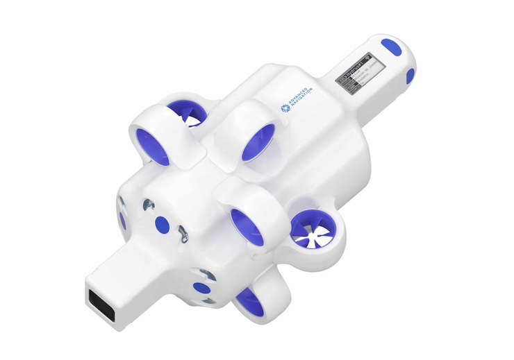
Other UUVs exist for dual-purpose underwater missions but none quite like the Hydrus. Just a half-meter in length and weighing a mere 7 kgs, the compact Hydrus can maneuver in tight spaces and conduct its operations autonomously – for a distance of up to 6 miles over several hours without the need for recharging. It also comes equipped with lights and thermal imaging cameras to allow it to film and gather data in dark murky waters at depth beyond what human divers can withstand. For its size, range, versatility and maneuverability – and despite its hefty starting price of $55,000, beyond the range of most hobbyists – the Hydrus simply can’t be beat.
The latest Hydrus simulation was autonomous in more than one sense. In most undersea operations, the surface vessel monitoring the UUV is a crewed ship that tethers the vehicle and also tracks its movements using shipboard sonar. In this case the Hydrus was linked to an autonomous surface vessel, or USV, further reducing operational costs while enhancing safety. The only manned operators were located at research stations located far from the front lines. A USV can sometimes capsize but it’s also built to re-right itself on the open sea. The latest Hydrus operation was conducted without the need for a seaborne presence of any kind. In a live warfare setting, autonomous mine and countermine operations of this kind could shield warriors from exposure to harm.
This was only the first in a series of planned simulations geared to seabed monitoring and identification. A single Hydrus was programmed to cruise above the ocean floor in a controlled grid search to detect pre-positioned objects mimicking underwater mines and explosives, The simulations were repeated several times – every 30 minutes – noting shifts in the positions of the identified objects between each drone sweep to better understand how shifting deep water currents, marine life and other factors can affect the movements of underwater objects like mines. The data from the phased simulations will be used to construct a comprehensive AI model that can adapt Hydrus operations to evolving seabed conditions with even greater precision and detail.
While acknowledging the Hydrus’ future military applications. Advanced Navigation is also pushing ahead with ongoing civilian uses of the drone that are proving invaluable to scientific researchers and explorers. Just last week, the Australian National Museum deployed a Hydrus off the coast near Perth to produce a detailed 3D map of a sunken sea vessel. The company also recently sold two Hydrus units to the Australian Institute of Marine Science, which will use them to inspect coral reefs in the North West Shelf off of Australia’s west coast. These specific missions are just the beginning of the far-reaching strategic vision that the company has for the Hydrus, once it’s fully developed and tested with even more advanced data collection systems.
“Hydrus has the potential to discover why some of the ocean’s greatest climate change events are occurring. This includes CO2 absorption, reef bleaching, new diseases, loss of sea life and biodiversity, coastal erosion, and fishery decline amongst others. Being able to regularly gather high resolution data will help us measure the severity of these devastating events. We can then respond proactively, constructively and decisively,” company officials say.
Last September, Advanced Navigation signed an agreement with KKR, a leading global investment firm, under which KKR will provide $68 million in Series B funding to the Company. The company, which recently joined a NASA moon landing mission, boasts 10 major global investors and has raised more than $85 to date. Its international advisory board is chaired by General David Petraeus (U.S. Army, Ret.), who formerly commanded US forces in Afghanistan.
|