
LiDAR: (Light Detection and Ranging) Working in Conjunction with Drones
It seems as if LiDAR technologies are having a huge moment right now. LiDAR is being used in everything from self driving cars to autonomous drones. LiDAR stands for Light Detection and Ranging and it is a system of sending out pulses of light to create measurements. The system measures how long it takes for the pulse of light to make a round trip, turning those measurements into accurately detailed maps. As Louay Eldada, the CEO and co founder of Quanergy explained, “Think of it this way – LiDAR sensors allow machines to see the world around them, similar to human eyes. When paired with software that can interpret the data the sensors are collecting (the brain), this gives these machines spatial awareness and the ability to react to given situations. The benefits of LiDAR are substantial. Not only can LiDAR see clearly in any weather or lighting condition (unlike cameras) and see in 3D (unlike 2D in cameras and 1D in radar) but the sensors can also be mounted on both static and mobile platforms.”
There are many companies investing in LiDAR technologies now because of these reasons. One such company dedicated to the development of LiDAR technologies is AstraLiTe based out of Louisville, CO. AstraLiTe was founded by Geoff Crowley, a entrepreneur who is known for the commercialization and development of technologies. Geoff brought on Jeffrey Thayer to be the Chief Technology Officer. Jeffrey is a Professor of Aerospace Engineering Sciences at the University of Colorado with 20 years of experience working with LiDAR technology. According to AstraLiTe’s website, their goal is to “Helping you acquire previously unavailable data in real-time, with unprecedented accuracy.”
AstraLiTe is able to do this with a 2 in 1 LiDAR system called AstraLiTe Edge that is small enough to attach to a drone. “ASTRALiTe’s patented 2-in-1 topo-bathy LiDAR overcomes the limitations of traditional bathymetric LiDAR, measuring underwater features at centimeter-level depth resolution. From coastal mapping and surveying, to infrastructure inspection and military logistics, the applications of our LiDAR are numerous and widespread.” They have just completed a third round of testing with this drone LiDAR system in Hawaii.
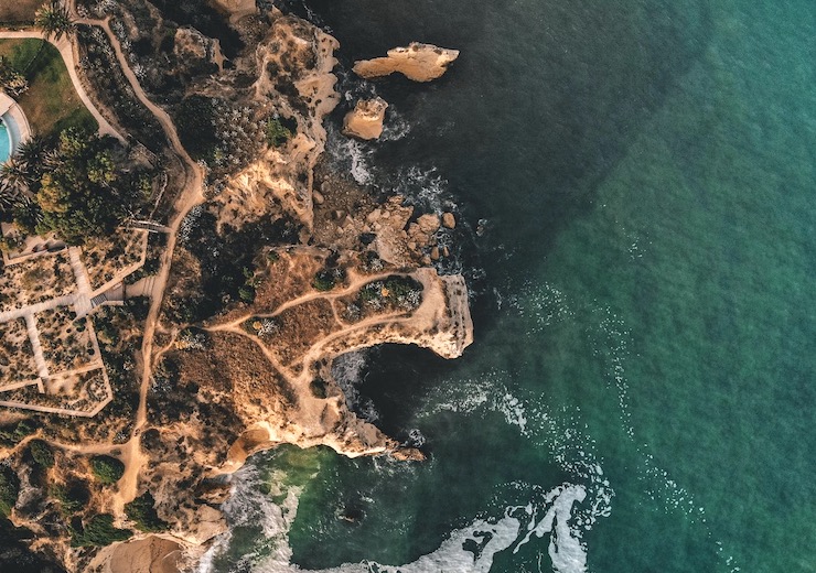
The first rounds of testing took place in their Colorado backyard. With help from local drone operations expert Juniper Unmanned, a drone was flown over a reservoir in Colorado for about 10-15 minutes collecting data. The second test took place at a higher altitude over the area where the Colorado River and Blue River converge. This mission was held in conjunction with the U.S. Geological Survey to document the flow of the two rivers as well as their depths, underwater obstruction and vegetation mapping. The final test took place off the coast of Coconut Island, HI with the Applied Research Lab at the University of Hawaii’s Institute of Marine Biology.
For the trials held in Hawaii they ran a total of 7 flights, the longest lasting for 17 minutes. On these flights the AstraLiTe Edge collected images of near shore depths, the profiles of dunes, lagoons, and inlets, and mapped underwater coral reefs at centimeter level resolutions. The drone was able to preform smoothly in windy conditions along with salt spraying from strong surf. The weather conditions proved no obstacle foe the LiDAR system. The drone used for all of these tests was the Matrice 600 Pro by DJI, a drone that can easily be purchased and operated.
The combination of drones and LiDAR system is allowing professionals to gather accurate bathymetric (underwater depths) data. Having these measurements provides organizations like the Navy, disaster recovery, coastal mappers, underwater infrastructure, and natural resource management with the means to preform their jobs efficiently, safely, and cost effectively. Gerald Thompson, ASTRALiTe’s vice president of operations, said “Bathymetry from a medium-sized UAV platform is now just as easy to perform as topographic LiDAR surveys. It’s a breakthrough to have a bathymetric scanning LiDAR system capable of working on the widely available DJI Matrice UAV. It opens up whole new business areas.
|