
Low-Flying Mapping Drones Can Better Predict the Paths of Wildfires, Limiting Property Damage and Loss of Life
Finding new means of controlling the nation’s wildfires is becoming an urgent national priority. The effects of climate change and the increasingly long dry summer months have left more landscapes and animal and human life at risk of perishing each year. Budget-strapped firefighters can use all the tools and technology at their disposal to limit the destruction to people and property.
Drones are slowly entering the nation’s fire-fighting arsenal, despite resistance from some state firefighting agencies that continue to rely exclusively on helicopters and fixed wing aircraft to shoulder the bulk of the work. Some of the resistance comes from highly-trained pilots that are reluctant to cede authority to remote operators and their small aircraft. There are also genuine concerns about “interoperability” – how to integrate manned and unmanned aircraft in a way that actually improves the efficiency of the firefighting operation without creating an additional safety risk.
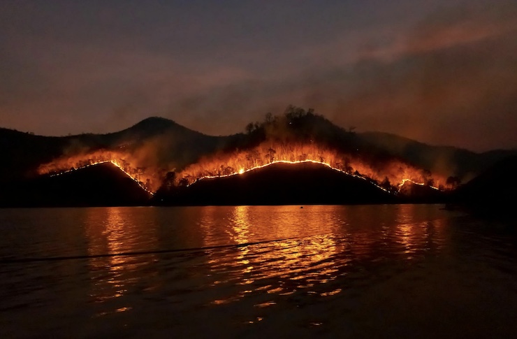
One obvious competitive advantage of drones is their aerial mapping capabilities. Flying at high altitudes, drones can aid existing firefighting operations by demonstrating where containment resources can initially be deployed and applied most efficiently. With 3D photogrammetry, they can also model the advance of the fire and predict its trajectory, allowing for more rapid containment. But most of the current military-grade drones being deployed also face a major limitation. Operating above the blaze, their cameras can be blinded by thick smoke that limits their ability to identify hot spots and specific ground structures most in need of emergency protection. Traditionally, firefighters use ground-based crews operating below the billowing smoke to provide the real-time tactical intelligence needed but the workers are limited by the intensity of the advancing blaze and the risks it poses to their own safety.
Researchers at Carnegie Mellon University’s Robotics Institute believe they have a solution to the problem: smaller, completely autonomous heat-resistant drones that can safely fly below the thick willowing smoke near ground level, avoiding trees and branches and using thermal imaging cameras to construct the same 3D photogrammetry models as the larger high-flying drones – but this time much closer to the blaze, without visual interference.
The drones have another important advantage: they can provide firefighters with a map of access and escape routes, while drawing attention to specific danger zones that might encircle them. The drones can literally save lives that are too often lost – about 100 annually, and growing – by firefighters getting too close to a fire and finding themselves trapped with no viable exit, researchers say.
Currently, CMU is testing the ability of its custom-built drones and their cameras to identify pathways during a fire and to create a “digit twin” of the landscape to aid emergency responders in real-time. Josh Wilkins, a retired firefighter and consultant to the project says, “I helped bury too many folks who died for lack of actionable information.” Firefighters are typically provided with 12-hour-old information when they begin their 12-hour shifts, he notes. By then, the information is outdated and poses a very real risk to their safety.
“There’s always resistance, particularly in the fire service, to drones,” Wilkins says. “But once we show them the safety factors that have been designed into these systems and the good data that we can collect with the drones, I think we’ll win them over.”
About 2,500 public safety agencies (PSAs) nationwide now deploy drones in fire-fighting roles, according to the Fire Apparatus Manufacturers’ Association. The nation’s drone fleet stood at roughly 10,000 two years ago but as more PSAs have come to appreciate their added value, the FAMA estimates that more than 30,000 will be in service by next year. With any luck, a growing share of those new drones will feature low-flying mapping capabilities currently being developed at CMU.
|