
NOAA and Black Swift Technologies Revolutionizing Hurricane Research with Drone Technology
For over 50 years, the National Oceanic and Atmospheric Administration (NOAA) has been tasked with providing the best scientific resources on all things weather-related. As the impacts of climate change have become apparent, much of what NOAA does revolves around the study of hurricanes, which continue to increase in severity. The 2024 Atlantic hurricane season began on June 1 and is set to conclude on November 30, with NOAA having predicted a particularly devastating season. It seemed as though their predictions would come true with the extremely rare early-season Category 5 Hurricane Beryl. However, NOAA experts became stumped when the hurricane season transitioned into a relatively mild event for the rest of the summer. Then, as Hurricane Helene began to gradually develop in the Caribbean, experts realized a potentially catastrophic storm would be heading toward the Big Bend region of Florida.
Making landfall on September 26, Category 4 Hurricane Helene became the strongest storm to hit the Big Bend region. So far, the storm has resulted in 113 deaths, with more than 1,000 people missing. News stations have been releasing drone footage of the unbelievable damage left in Helene’s wake. But news crews were not the only ones equipped with drones. In anticipation of the possibility of Helene becoming a record-breaking storm, NOAA planned to use drones to further understand the phenomenon of the 2024 Atlantic hurricane season.
This was far from the first time NOAA used drones to study hurricanes. For some time, they have been deploying single-use drones from aircraft as well as water-surface drones to collect storm data. “One of the largest challenges in hurricane research is studying the inner dynamics of a storm,” NOAA explains. “The regions within the hurricane that provide the most valuable data are often the most inaccessible and dangerous to reach, creating an opportunity for researchers to utilize emerging technology to enter the storm.” Water-surface drones are extremely helpful, but the aerial drones NOAA has been using can only collect a few seconds of data.
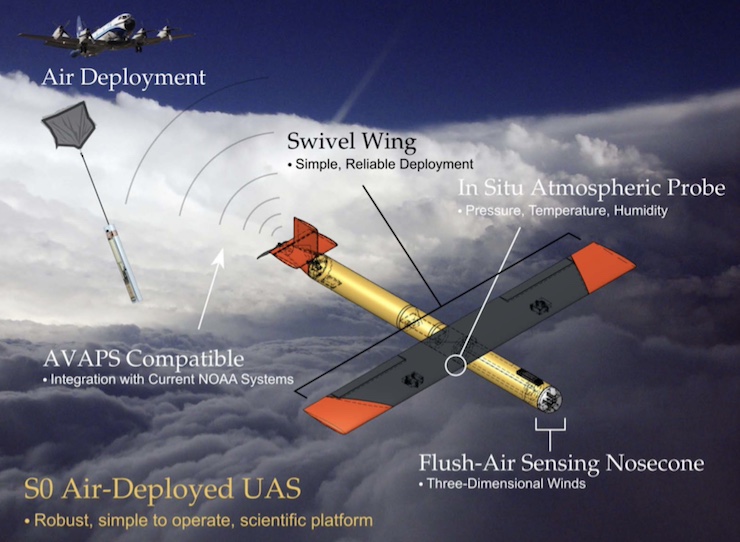
That is why NOAA has partnered with Black Swift Technologies, based out of Boulder, Colorado. University of Colorado Boulder graduate Jack Elston founded Black Swift in 2011 to bring “reliable, robust, and highly accurate unmanned aircraft systems (UAS) capable of flying scientific payloads in demanding atmospheric environments (high-altitude, arctic, desert, corrosive particulates, and strong turbulence),” as stated on the company website. Black Swift’s SO Air Deployed drone is a low-cost, disposable drone perfect for gaining access to the most dangerous parts of a hurricane.
The drone weighs 2.6 lbs and is housed in a biodegradable tube. The tube is launched from a plane into a storm. When in the desired position, the drone is released from the tube, its wings unfold, and it keeps pace with the storm rather than dropping into the ocean a few seconds after deployment. “We can control its flight using a tablet, but we built in some pretty smart algorithms that allow the drone to fly itself,” said Elston. “Usually, the meteorologists have a predetermined pattern that they want it to fly, so we just program that in for them.”
Elston was onboard the NOAA P-3 hurricane hunter plane to launch one of his drones during the 2023 Tropical Storm Tammy. Then, during 2024’s Hurricane Ernesto, Elston was on hand to launch four of the drones, which went on to collect a record amount of data with the drone’s array of onboard sensors. According to a NOAA press release, “Across all four flights, the Black Swift gathered about 200 minutes of data, with the longest flight reaching a total time of 77 minutes. The flights into Hurricane Ernesto set a new record in hurricane research; the SO now holds the record for maximum sustained communications range between a NOAA P-3 and a sUAS of 143 nautical miles.” The team once again gathered to launch Black Swift drones into Hurricane Helene.
As we continue to confront the challenges posed by increasingly intense hurricanes, integrating drone technology into meteorological research is proving invaluable. By enhancing our understanding of these powerful storms, NOAA and its partners are not only improving predictive capabilities but also helping communities better prepare for the impacts of climate change. As Joseph Cione, NOAA’s lead meteorologist for emerging technologies, said, “I can imagine a future where we have drones launching drones. We are taking baby steps toward that.” The collaboration between NOAA and Black Swift Technologies is just the beginning of the possibilities drones will bring to shaping weather-related research.
|