
Scott Polar Research Institute Using Drones to Study the Impact of Moulins, Rising Sea Levels, and Climate Change
In 1920, University of Cambridge Professor of Geography, Frank Debenham, founded the Scott Polar Research Institute (SPRI). It was named in honor of Royal Navy Captain Robert Falcon Scott who died along with his crew on a journey returning from exploring the South Pole in 1912. The institute went on to become one of the leading geological and glacial research centers, spearheading groundbreaking studies in the polar regions. When SPRI was founded, geologists would use tools like hammers, chisels, sextons, and clunky cameras to conduct research. Today, under the directorship of the University of Cambridge Professor of Physical Geography, Jullian A. Dowdeswell, SPRI has a wide range of advanced technology to study glacial, atmospheric, and climate changes in the polar regions.
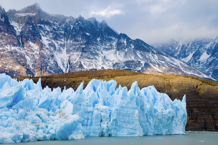
Recently, a team of researchers from SPRI announced that they had witnessed a phenomenon on the Greenland ice sheet with the help of specially designed drones. Spanning more than 1,800 miles long and 680 mile wide, the Greenland ice sheet is the second largest body of ice in the world. If the entire ice sheet were to melt, it would lead to a 24 ft rise in the global sea level. Between 1979 and 2002, scientists measured that ice melt increased by 16%. Many scientists fear that a global increase in temperatures of only 2-3 degrees could lead to the entire sheet melting and Greenland becoming completely submerged. This is why the Greenland ice sheet is of particular interest to those studying climate change.
One of the main contributors to ice melt on the sheet is the formation and drainage of surface lakes during the summer. These surface lakes form moulins, tunnel like shafts that drain melt water into the ocean. The combination of surface lakes and moulins can rapidly melt large sections of ice. Because it happens so rapidly, the occurrence has also been difficult to document for study. Dr. Poul Christoffersen and a team of researchers arrived at the Store Glacier in Greenland in July of 2018 to try and get visual footage of how moulins affect rapid ice melt and increased sea levels. One of the members of the team was graduate student Tom Chudley along with his drone.
A few days after making camp on the glacier, Tom sent the drone up to scan for possible moulins. Through the drone’s camera, he identified a fracture that led to a large blue spot in the ice. While the spot looked like a lake, the team quickly realized that it was a moulin that would be draining water into the sea below. Tom proceeded to take thousands of images with the drone for 5 hours. The final images captured by the drone showed a blue spot that was dramatically smaller from the starting image. Over the 5 hours, five million cubic meters of water rushed through the fracture, down the shaft of the moulin, and into the sea. That is enough water to fill close to 2,000 Olympic sized swimming pools. As the melt water rushes into the sea, it causes the glacier to rise and move faster.
The drone Tom used was far from an off the shelf commercial drone. As part of his NERC (National Environmental Research Council) funding, Tom had a drone custom built for the mission. The drone needed to be able to hold up to the extreme temperatures and winds of the Arctic. It was equally important to have cameras and sensors that could also handle these conditions. The drone also needed to have autonomous flight abilities and a battery that could fly up to an hour at a time, all while being low cost. Tom’s resulting drone is a robust, insulated glider that supports cloud-based geospatial platforms.
The footage Tom captured with his drone was the first of its kind in glacial studies. “It’s possible we’ve underestimated the effects of these glaciers on the overall instability of the Greenland Ice Sheet,” Tom said. “It’s a rare thing to actually observe these fast-draining lakes, we were lucky to be in the right place at the right time.” It also helped that they had the right equipment, a drone, to document the phenomenon. Tom and his colleagues from SPRI have continued using drones on Store Glacier to study the impact of moulins, rising sea levels, and climate change. Before using drones, researchers had to rely on data provided by satellites. But as Tom pointed out, satellite images are great for getting a general idea of what is happening on the ice sheet, “but drone-based observations give a lot more nuance to our understanding of these lake drainages. We can also observe the formation and re-opening of fractures, which isn’t possible from satellites.” Through using emerging technology like drones, SPRI is keeping the vision of its founder alive, to be a premier research institute delving into how the Arctic regions support life on Earth.
|