
Using Drones to Map Out and Monitor Volcanoes
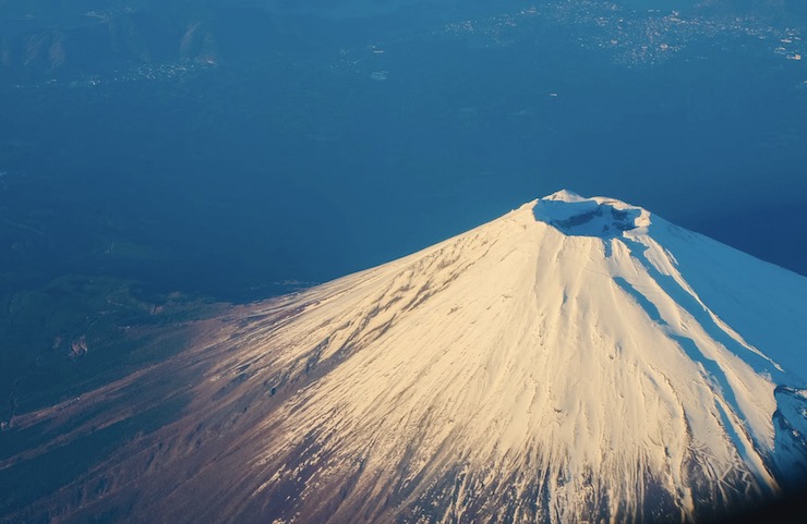
There are over 1,000 potentially active volcanoes above sea level on Earth, with far more spreading along the ocean floors. Of these above ground volcanoes, 500 of them have erupted during recorded historical time. Volcanologists categorize volcanoes into three categories based on their activity as active or potentially active, dormant or inactive, or extinct. One of the most active volcanoes in the world can be found in the western highlands of Guatemala, the Santa María Volcano which has been continuously active for over 100 years. After remaining dormant for at least 500 years, Santa María erupted on October 24, 1902, an event that lasted for a full two days. The eruption was one of the third largest volcanic eruptions of the 20th century and the fifth largest in over 200 years.
Like other volcanoes throughout the world, volcanologists have been studying Santa María for decades. However, since volcanoes are such volatile environments, getting close enough to study them has been difficult, to say the least. Besides the extreme temperatures near a volcano, researchers also have to deal with extreme weather patterns, unstable terrain, and toxic gases in the atmosphere. With the continued advancement of drone technology, researchers are finally getting in close to volcanoes to gather valuable data. A team of researchers from the German Research Centre for Geosciences (GFZ) lead by Edgar Zorn just released their findings on a study of the Santa María Volcano that they were able to complete with the use of drones.
Using a DJI Phantom 4 Pro, Edgar and his team were able to fly the drone close enough to the volcano while remaining at a safe distance. The focus of their study was on the volcano’s lava dome. A lava dome is a plug like center at the top of a volcano that consistently pushes out lava. Being able to climb to a peak like this is unrealistic, and using manned aircraft to examine it is dangerous, ineffective, and costly. With modifications to protect the sensitive equipment on a drone, it can easily access views of a lava dome. “We have equipped a drone with different cameras,” Edgar said. “We then flew the drone over the crater at various intervals, measuring the movements of lava flow and a lava dome using a specific type of stereo photography with a precision never seen before.”
With GPS, the Phantom 4 is able to fly to a set coordinate with a tap of a button. It is lightweight and easy to use. For an off the shelf drone, it is a remarkably high quality tool perfect for hobbyists and professionals alike. With the drone’s sRGB camera, the team was able to capture images of the highest quality, even through the dense air at the peak of the volcano. The team from GFZ also attached a FLIR TAU 2 thermal imaging camera to the drone to get precise data as to what was happening in the lava dome. The drone was flown over the crater several times to survey the area. When it returned, all of the optical and thermal images were uploaded to a computer and an algorithm compiled a wealth of data to be studied.
The images taken by the drone were turned into 3D models of the volcano, including a 3D topography and temperature model. These models allowed Edgar and his team to study the volcano’s flow velocity as well as the movement patterns and surface temperatures. They were also able to determine that the lava dome changes on two different time scales. The lava dome has a period of slow growth and expansion mixed with times of rapid ejection of viscous lava. Together this data will allow for volcanologists to create better predictive models for volcanic activity.
This is just the beginning of the research possibilities for volcanoes. “We have shown that the use of drones can help to completely re-measure even the most dangerous and active volcanoes on Earth from a safe distance,” remarked Edgar. One of Edgar’s colleges from the study, Thomas Walter, believes that drones will lead to a new wave of volcanology. He said, “A regular and systematic survey of dangerous volcanoes with drones seems to be almost within one’s grasp.” As there are active and potentially active volcanoes all over the world, this is critical to ensure the safety of the communities that surround them.
|