
GrandSKY Drone Weather Research Project by UND Researchers Using Meteodrones
© GrandSKY & Und.edu
GrandSKY drone weather research is helping advance forecasting and unmanned aircraft safety in the United States. Located on Grand Forks Air Force Base in North Dakota, GrandSKY is the nation’s first commercial unmanned aerial systems business and aviation park. Since 2015, it has provided secured airspace, hangars, and office space connected to a runway for testing and operations. By collaborating with the Northern Plains UAS Test Site, one of the FAA’s original drone testing sites, GrandSKY has enabled BVLOS operations, waiver support, and safety oversight, making it a cornerstone for drone innovation.
Nearby, the University of North Dakota (UND) and the John D. Odegard School of Aerospace Sciences have built close ties with GrandSKY. This collaboration has advanced drone applications in both academia and industry. One example is UND Aerospace’s partnership with Vigilant Aerospace Systems, which uses Vigilant’s FlightHorizon software to improve drone safety and situational awareness in shared airspace.
GrandSKY Drone Weather Research: Meteodrone Atmospheric Observation Project
Recently, Dr. Chrit and fellow Research Assistant Professor Dr. Marwa Majdi, along with graduate student Claiborne Wooton, completed another drone study at GrandSKY called the Meteodrone Atmospheric Observation Project. The goal was to test and refine drone-based methods for collecting real-time weather data in the lower atmosphere, providing critical measurements that can improve forecasting models and support safe operations for unmanned aircraft.
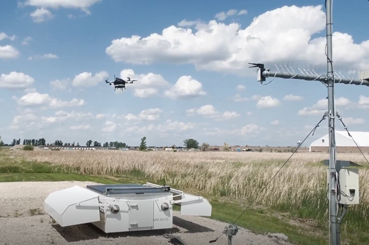
The project involved a series of coordinated flights in which the research team collected detailed atmospheric data at multiple altitudes above GrandSKY. By integrating the drone’s measurements with information from the ground-based Meteobase station, the team studied the structure and behavior of the atmospheric boundary layer in ways not possible with traditional methods. “Our goal was to demonstrate that drones can provide reliable, high-resolution weather data that fills gaps in existing observation networks, especially in areas where conventional sensors are limited,” Dr. Chrit explained.
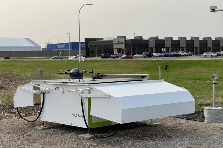
Meteodrones and Advanced Weather Sensing
Developed by the Swiss weather technology company Meteomatics, Meteodrones are small unmanned aerial vehicles engineered for atmospheric research. These drones carry advanced sensors capable of monitoring temperature, humidity, pressure, wind speed, and icing conditions. They can be deployed repeatedly with precise control to collect data from targeted areas, providing high-resolution weather information that complements forecasting models while supporting safe operations for both manned and unmanned aircraft.
© GrandSKY & Und.edu
Operating in Shared Airspace
Conducting the Meteodrone project in critical shared airspace, including near Grand Forks International Airport, added complexity and importance to the research. Operations required coordination with air traffic control and adherence to FAA regulations, including BVLOS waivers and risk mitigation protocols. This ensured safety while offering a practical model for integrating drones into congested airspace. “Flying in real-world airspace gives us insights into both the technical and regulatory challenges of UAS operations,” Dr. Chrit said. “It helps inform best practices for safe integration.”
Expanding the Role of Drones in Science
The Meteodrone Atmospheric Observation Project highlights the expanding role of drones in scientific research and airspace management. By combining UND’s expertise in atmospheric sciences with GrandSKY’s infrastructure, the project showed how unmanned aircraft can safely deliver valuable weather measurements. The insights gained will improve forecasting, guide operational decision-making, and serve as a model for collaborations between universities, industry, and regulatory agencies.
As drone technology continues to evolve, initiatives like this illustrate the potential of unmanned systems to advance our understanding of the atmosphere while supporting safe, integrated operations in shared national airspace.
|