
Scientists Using Drones to Count The Walrus Population
Being able to have accurate counts of different animal populations throughout the world is just one of the many ways scientists take measures of our ever changing planet. These population counts are particularly vital in understanding how climate change impacts the world. An example of one of these counts is the populations of walruses that are dependent on the rapidly decreasing polar icecaps.
As explained by Rod Downie, Chief Polar Advisor at WWF-UK, “Walruses are an iconic species, of immense cultural significance to Arctic people. They are big, powerful animals, yet they are also increasingly vulnerable to the effects of climate change as the sea ice is literally melting out from underneath them. What we are trying to do is better understand walruses, how they are responding to the climate crisis now and how they might respond in a climate altered future. We are doing this to provide evidence to support the conservation of the species across its range.”
For the past decade, the British Antarctic Survey (BAS) has been a leading example of how to use remote technology to conduct these research projects. For years they have been collecting and analyzing satellite imagery to understand the population habits of walruses and other arctic species. While satellite images have provided vast amounts of data, there are still some gaps that research teams are trying to fill.
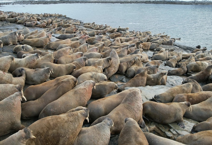
In a report released on May 22, 2024, a team of scientists from BAS, the Norwegian Polar Institute, and citizen scientists revealed that they made huge leaps in walrus population counts with the addition of images captured with a drone. The report explains how walruses tend to haul out onto the same shores during the late summer through early fall. With this in mind, the teams ventured out to Sarstangen in Norway’s Svalbard Archipelago.
To conduct the population count, scientists need to maintain a safe distance so as not to spook the walruses. In the past, using images collected from boats or planes has been inaccurate because the walruses are sensitive to the sounds made by such vehicles. This is why for the past five years scientists have been using satellite images as part of the BAS’s greater program known as Wildlife From Space.
The satellite captures Very-High-Resolution (VHR) images repeatedly over short bursts of time. The images are then examined by professional and volunteer citizen scientists. While the images collected every 15 minutes are VHR, the teams had no way of knowing just how accurate their walrus count was. Walruses tend to gather in heaps and piles, which makes counting individual walruses difficult. So this year, BAS scientists Peter Fretwell and Hannah Cubaynes added images collected by a drone to help count the population.
While Peter operated the DJI Mavic 3 drone with an HD camera, Hannah kept track of the time and location data. The images collected by the drone were then synched with the time and location of the images taken by the satellite. The drone was able to get close enough to the walruses, while still maintaining a distance so as not to spook them. And, the drone’s camera was strong enough to capture images clear enough to identify individual animals.
“Thanks to the team’s perseverance,” Hannah said, “we were able to get an on-the-ground drone image within minutes of a satellite image taken from space. This was totally unprecedented and the best result we could have hoped for. This is a really exciting development for the project—giving us almost like-for-like satellite and drone images that we can use to calibrate walrus counts from both experts and citizen scientists.” Upon comparing the drone and satellite images, the teams found that they had undercounted walruses from the satellite images.
Ultimately, using the combined efforts of satellite and drone imagery, conservationists will have the data needed to gather proper population counts. These counts will go on to provide more than an insight into how climate change is progressing and affecting arctic animal populations. It will also give conservationists the information needed to implement safeguards for these animals.
|