
Using Drones to Track Rhinoceros by Analyzing Their Foot Prints
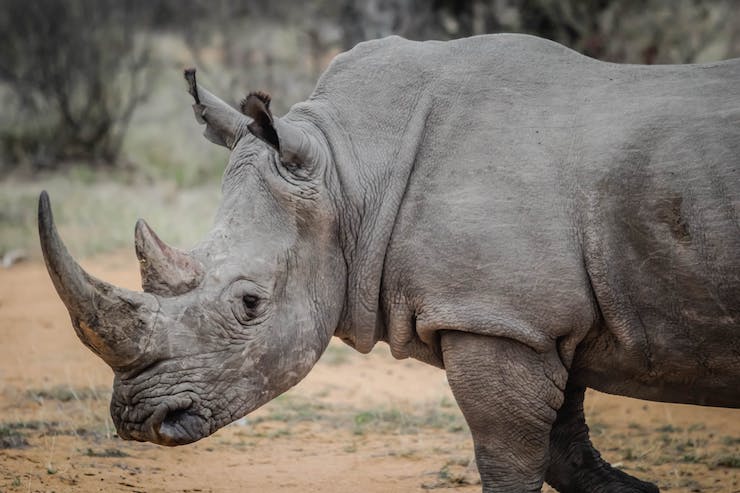
On March 19, 2018 Sudan, a northern white rhinoceros, died in Kenya. Sudan was the last known male northern white rhinoceros in the world. Currently there are only two females of the species known to be alive, both of whom are in captivity. The southern white rhinos are faring much better and as of now are supporting numbers to keep them off of any worrisome endangerment lists. However the black rhinoceros of eastern and southern Africa have been ranked as critically endangered by the International Union for Conservation of Nature (IUCN). Three of the eight subspecies of black rhinos have already gone extinct while a fourth, the Chobe black rhino, is believed to have only one surviving specimen in the wild. Conservationist from all over the world are working to study these majestic animals in the hopes of learning how to protect them.
Zoe Jewell and Sky Alibhai began studying black rhinos in Zimbabwe in the late 90’s. At that time the most common way to track the animals and monitor their behaviors was by shooting them with tranquilizer darts and placing electronic collars on them. It didn’t take long for Zoe and Sky to realize there was a major setback to this method. As Stuart Pimm, a professor of conservation ecology at Duke University, said “If you were walking through your neighborhood and suddenly a bunch of strange people came charging after you … and you got shot in the ass with a dart and woke up with something around your neck, I think you’d be in pretty bad shape too.” The collaring method was proving to be too stressful on the female rhinos and they began producing fewer offspring, dramatically lowering the population.
Zoe and Sky knew that there had to be another way for them to conduct their research. While working along with the Shona tribe in Zimbabwe the pair came up with an idea. Zoe recalled how “We would go out with local game scouts, who were often expert trackers, and they would often laugh at us as we were listening to these signals coming from the collars. They would say to us, all you need to do is look on the ground.” These native experts were able to correctly determine the sex, weight, and specific species all from looking at the tracks left in the ground. Never did they need to use invasive collars to study them.
In 2004 Zoe Jewell and Sky Alibhai created WildTrack, a company that monitors wild life through non-invasive measures. They do this through a program they call FIT, Footprint Identification Technology. This is based off of the methods they learned from indigenous trackers in Zimbabwe. A photo of an animal track is uploaded to their system. The system then uses a complex algorithm to determine the species, subspecies, sex, weight, and individual characteristics. All of this data adds up to a collection that allows conservationist to safely monitor wildlife. The only problem is that the collection of these images is extremely time consuming.
Recently WildTrack has partnered up with SenseFly, a branch of the European drone company Parrot. They began testing SenseFly’s eBee X drone to collect data rather than spend hours completing field work. As stated on SenseFly’s website, “The eBee X is the fixed-wing drone for all your mapping needs. Designed to boost the quality, efficiency and safety of your data collection, it has a camera to suit every job, the accuracy and coverage to meet every project’s requirements, and can work virtually every type of site.” WildTrack needed a drone that could accurately locate tracks, photograph them, and map the area without disturbing the data. They tested this process along a beach in North Carolina and the eBee X proved up to the job. The drone was able to locate and identify human, dog, and horse tracks in the sand without disturbing the tracks like a drone with propellers would. The drone was also able to create an orthomosaic map of the area. This map provided the researchers with far more information than they would be able to collect manually in a fraction of the time.
With the success of the test in North Carolina, WildTrack will be heading to Namibia with the SenseFly eBee X drone to track one of the remaining black rhino populations. The drone will be used to map the terrain that protects the rhinos, monitor the tracks and behaviors of the animals, monitor the ground conditions for any irregularities, and monitor against illegal poaching.
Fortunately for WildTrack the US government has taken an interest in the methods they plan to use for non-invasive animal tracking. The US government is helping to fund this mission as a long term investment. Zoe said, “Biodiversity is disappearing at 1000 times background rates, yet we totally depend on biodiversity for our own survival. We threaten our own existence when we fail to protect the other species that inhabit this planet.” A sentiment that the US government strongly supports. She went on to state, “We feel very encouraged that the U.S. Army Research Office is working with us to support the conservation of endangered species and glad that we have a common mission.”
|