Drone photography is a form of aerial photography that uses unmanned aerial vehicles equipped with stabilized, high-resolution cameras to capture images and video from bird’s-eye viewpoints. Its roots trace back to early airborne imaging experiments in the 1800s and military reconnaissance during World War I and II. Over time, advances in GPS, battery efficiency, gimbal stabilization, and camera technology transformed drone photography into an accessible and reliable visual tool.
As drone technology has become more accessible, drone photography is now priced by the hour, on a flat fee, or as a package deal, with prices ranging from $70 to $3,000. This flexible pricing has made drone photography a valuable asset across different industries, including real estate.
Modern drone photography combines technical control with creative planning. It requires knowledge of camera settings, flight operation, legal regulations, and specialized equipment, while accounting for environmental and technical limitations. By balancing cost efficiency, safety, and visual impact, drone photography has become a practical solution for both creative projects and professional documentation.
How Did Drone Photography Evolve Over Time?
Drone photography began in the 1800s with early aerial photography experiments using airborne cameras attached to kites and balloons to capture images from altitude. In 1858, Gaspard-Félix Tournachon created one of the earliest balloon-based aerial photographs, followed by Julius Neubronner, who developed pigeon-mounted cameras.
These methods proved the value of elevated viewpoints but lacked flight stability, precise control, and the ability to hover. During World War I and World War II, the military application of aerial photography expanded, as aircraft-mounted cameras recorded terrain for reconnaissance, accelerating improvements in camera quality and reliability.
From the 1940s to the 1970s, military research and space exploration advanced specialized cameras, exposure control, and stabilization. These innovations improved flight stability concepts and established technical standards for unmanned imaging systems.
Between the 1980s and today, advances in miniaturized electronics, GPS, batteries, and camera technology have made drones smaller, more stable, and more affordable. In the 2010s, companies such as DJI introduced ready-to-fly drones with high-resolution cameras and gimbal stabilization, enabling steady hover and clear aerial photos. These improvements positioned drone photography as a practical alternative to costly helicopter shoots in real estate, filmmaking, and construction.
How Much Does Drone Photography Cost?
The cost for drone photography ranges from $70 to $3,000, with pricing based on models such as hourly rates, packages, or flat rates. Additionally, the overall drone photography cost is influenced by shoot complexity, location, duration, equipment used, the drone photographer’s experience, and post production requirements.
Drone photography costs based on different pricing models:
- Hourly Rates
Hourly rates for drone photography range from $70 to $500+ per hour, depending on the drone photographer’s experience, required equipment, location, and project complexity. Beginner or entry-level drone photographers charge $70 to $150 per hour, while standard and skilled professionals charge $150 to $250 per hour. And if you are looking for more advanced options, it can cost $250 to $500 or more, as they offer features such as cinematic, mapping, and inspections. - Flat Rates
Under a flat-rate pricing model, drone photography costs generally range from $200 to $3,000 per project. This model is common for real estate listings, construction progress shots, or small commercial shoots. Pricing depends on factors such as the number of aerial photos, location, flight duration, and basic post-processing, providing predictable costs for standard requirements. - Package Deals
Package deals for drone photography start at $500 and go up to $2,000+, combining multiple services such as aerial photos, video, basic editing, color correction, post-processing, and multiple flight sessions. into one offering. These packages often include multiple flights, aerial photos and video, advanced camera settings, and post-processing. Package pricing is commonly used for events, marketing campaigns, and cinematography projects that require extended coverage and consistent visual output.
What are the Uses of Drone Photography?
Drone photography is used across multiple sectors, including real estate, for capturing unique aerial perspectives, stable motion, and high-resolution visuals that traditional ground-based photography lacks. For example, in commercial real estate photography, drones operate at controlled altitudes and angles to provide clear visual context, accurate scale, and spatial continuity. This allows professionals to communicate property features, site layout, and surrounding infrastructure more effectively while documenting environments with greater visual impact.
Uses of drone photography:
- Unique Vantage Points
Drone photography enables capturing images from heights and angles that ground-based cameras cannot reach, and that satellite imagery cannot resolve. As a result, familiar landscapes take on new visual meaning by revealing patterns, geometry, and scale that are otherwise hidden. For example, a top-down nadir shot of a winding coastal road or a low-altitude glide over a forest canopy creates a perspective that reminds us that aerial views can be both immersive and informative at once.
- Cinematic Motion
Drones utilize advanced 3-axis gimbals to produce perfectly smooth tracking, pan, and orbit shots that support cinematic motion. This technical stability allows creators to follow moving subjects with precision or execute complex maneuvers, such as a dolly zoom, without disrupting visual flow. By stabilizing the drone camera during high-speed movement, filmmakers gain consistent control over framing and emotion that was once limited to expensive aerial rigs.
- Event Coverage
Utilizing drones for events allows for capturing the full scope of large-scale gatherings without the intrusive presence of cranes or scaffolding that might obstruct attendees’ views. This aerial approach preserves the event’s natural atmosphere while still documenting its scale. It is particularly effective for recording the size of a music festival crowd or capturing an outdoor wedding ceremony set within a wide landscape.
- Real Estate
In real estate, drone photography provides a 360-degree view of a property and its surrounding neighborhood, enhancing property listings through visual context. According to RubyHome, homes with drone photography and videos sell 68% faster than those without. This faster sales cycle is largely driven by clearer visual information, as aerial images from real estate drone photography highlight property boundaries, roof conditions, and access roads.
- Journalism & Film
Drones offer breaking news teams and documentary filmmakers immediate, safe, and efficient aerial access to disaster zones and hard-to-reach locations. This capability supports timely visual reporting without exposing crews to unnecessary risk. Whether live-streaming flood damage for news broadcasts or filming action sequences in dense urban spaces, drones allow coverage of fast-moving situations where safety or logistics would otherwise limit access.
What are the Types of Drone Photography?
Different types of drone photography are classified based on camera angle (vertical, oblique), specialized technology (multispectral, LiDAR), and industry application (real estate, photogrammetry). Each of these drone photography types serves a distinct purpose, helping professionals capture aerial images that support analysis, documentation, storytelling, or visualization across different fields.
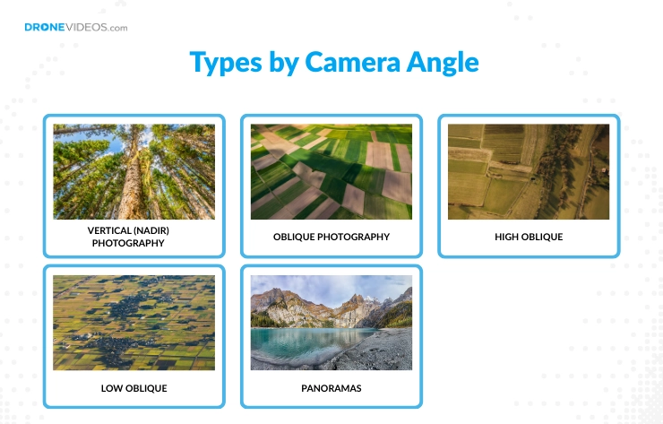
1. Types by Camera Angle
- Vertical (Nadir) Photography: This type captures images straight down (nadir) from above and is used for mapping, land surveys, and photogrammetry as it provides accurate scale and alignment.
- Oblique Photography: Captures images at an angle (between 30° and 60°) rather than directly downward. It provides a more natural, three-dimensional view of the landscape that is easier for the human eye to interpret.
- High Oblique: A specific type of oblique shot that is angled downwards but not straight down. They are commonly used to show large areas such as cityscapes or infrastructure layouts.
- Low Oblique: Low oblique photography is captured at lower altitudes with a shallow angle. It emphasizes foreground details and is often used in cinematic and promotional visuals.
- Panoramas: These are created by stitching multiple images together to create a wide-angle or 360° field of view. They are used to provide immersive virtual tours or to capture vast landscapes that a single frame cannot contain.
2. Types by Specialized Technology
- Multispectral & Hyperspectral: These sensors capture specific wavelengths of light, such as Near-Infrared, across 3–10 distinct bands or hundreds of narrow, continuous bands. This technology allows the identification of chemical compositions and biological health indicators that are invisible to the naked eye.
- Thermal (Infrared): These cameras detect heat signatures rather than light. They are invaluable for Search and Rescue (SAR) to find missing persons at night, or for industrial inspections to spot overheating power lines and heat leaks in building insulation.
- LiDAR (Light Detection and Ranging): LiDAR uses laser pulses to measure distances, creating highly accurate 3D point clouds. Unlike standard cameras, LiDAR can penetrate dense tree canopies to map the ground surface underneath, making it the gold standard for forestry and archaeological surveys.
3. Types by Industry Application
- Real Estate & Architecture: In real estate and architecture, drone photography is used to document properties, building designs, and surrounding environments from above. Aerial images help showcase property boundaries and neighborhood context, supporting marketing and planning.
- Photogrammetry: Photogrammetry uses drone-captured aerial images to generate accurate 2D maps and 3D models. This application supports land surveying, construction planning, and infrastructure measurement by converting overlapping images into precise spatial data.
- Cinematography: Focused on storytelling and emotion, this application uses drones as flying dollies to achieve smooth, high-speed tracking shots for films, commercials, and music videos.
- Environmental & Conservation: Drones are used to monitor wildlife populations, track coastal erosion, and document the effects of climate change in remote areas without disturbing the local ecosystem.
What Are the Best Tips for Drone Photography?
To get the best shots from your drone photography, start by choosing the right drone, reading the manual, looking for features, familiarizing yourself with the laws, and creating a checklist for the flight. These practical tips help both beginners and experienced drone photographers improve flight control, image quality, and overall shooting consistency, while reducing common mistakes during drone photography sessions.
Tips for best drone photography:
- Select a drone that matches your skill and requirements
Choosing the right drone is important for safety, control, and image quality. Starting with a drone beyond your skill level increases crash risks, while an underpowered drone may limit your creative output. A beginner should start with a sub-250g drone like the DJI Mini 4 Pro for its ease of use and lack of registration hurdles, while a professional can opt for the DJI Mavic 4 Pro or Inspire 4.
- Carefully read the user manual of your drone
Every drone has unique emergency procedures, limits, flight modes, and battery maintenance requirements. Therefore, understanding these specifics before your first flight prevents costly hardware failures.
- Familiarize yourself with the features and functions of your drone
Before taking the flight, take your time to understand all of the drone’s feature including GPS capabilities, flight modes, and camera controls. Additionally, spend time in an open field testing “Return-to-Home” (RTH), obstacle avoidance sensors, and “Auto-Exposure Bracketing” (AEB) to understand how the drone behaves in different scenarios.
- Learn about the drone laws and regulations in your area
Within the US, every drone weighing over 250g (0.55 lbs) must be registered, and all drones, regardless of weight, must have Remote ID enabled to fly legally in the National Airspace. Additionally, all recreational flyers must pass the TRUST (The Recreational UAS Safety Test), while commercial pilots must maintain a valid Part 107 license. Always check for Temporary Flight Restrictions (TFRs) and No-Fly Zones using the official B4UFLY app before every takeoff.
- Create a checklist before each flight to ensure everything is ready
A pre-flight checklist, whether physical or digital, helps verify battery levels, weather conditions, memory storage, and controller connectivity. This preparation supports stable flight, reduces technical issues, and helps ensure safe and consistent drone photography sessions.
- Practice flying your drone to get comfortable with its controls
Drone mastery comes from repetitive practice, so focus on flying in Cine mode for smooth movement and Sport mode to understand the drone’s maximum responsiveness and wind resistance.
- Master essential drone photography techniques
Focus on composition by using the rule of thirds grid for balanced framing and capture nadir shots by pointing the camera 90 degrees downward to reveal patterns. Also, use AEB (Auto Exposure Bracketing) to combine multiple exposures into well-exposed HDR images during post-processing.
- Edit your photos after the shoot for enhanced quality
Raw drone images often look flat, so to enhance their quality, use software like Adobe Lightroom or Luminar Neo to correct lens distortion, reduce noise from small sensors, and apply color grading to bring the aerial scene to life.
What are the Challenges of Drone Photography?
The main challenges of drone photography include environmental and technical factors such as weather conditions, legal and logistical constraints tied to drone laws, and creative or piloting difficulties related to flight control. Understanding these challenges helps drone photographers plan more effectively, reduce risk, and maintain consistent image quality throughout a drone photography session.
3 main challenges of drone photography:
- Environmental & Technical Hurdles
Environmental factors such as strong winds, rain, fog, extreme temperatures, collisions with obstacles, and wildlife interference can affect drone flight safety and image quality. Technical limitations follow closely, including short battery life, restricted range and altitude, fixed wide-angle lenses that require repositioning for framing, and payload constraints that reduce stability and flight time. - Legal & Logistical Issues
Drone photography faces legal and regulatory challenges that control where and how flights occur. No-fly zones around airports, military bases, and government buildings can restrict access. Commercial drone photography often requires proper licensing, pilot certification, and drone registration, while privacy laws may restrict flying over private property without consent. Understanding and complying with these requirements helps avoid legal issues and operational delays. - Creative & Piloting Challenges
Creative and piloting challenges, such as unstable flight control, abrupt movements, poor composition, and incorrect camera settings, can reduce image quality even with advanced drones. These issues often arise from limited flight practice or a lack of shot planning, making smooth control and consistent framing harder to achieve during a drone photography session.
What Are the Benefits of Drone Photography?
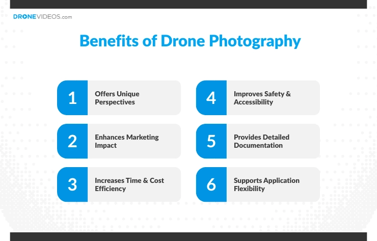
The benefits of drone photography are its unique aerial perspectives, enhanced marketing impact, cost efficiency, improved safety, detailed documentation, and flexibility.
6 benefits of drone photography:
- Offers Unique Perspectives: Captures bird’s-eye views that reveal scale, layout, and context impossible from the ground, making visuals more engaging and informative.
- Enhances Marketing Impact: Delivers high-resolution aerial images and video that increase visual appeal and audience engagement in real estate, advertising, and media.
- Increases Time & Cost Efficiency: Replaces helicopters, cranes, and scaffolding, reducing setup time and overall project costs.
- Improves Safety & Accessibility: Accesses hazardous or hard-to-reach areas without putting people at risk, supporting safer inspections and documentation.
- Provides Detailed Documentation: Produces accurate aerial records of sites, progress, and conditions, supporting planning, monitoring, and reporting.
- Supports Application Flexibility: Adapts to diverse use cases across industries, including mapping, filmmaking, marketing, and environmental monitoring.
What are the Best Camera Settings for Drone Photography?
For the best drone shot, using the right camera settings, including RAW format, low ISO, proper aperture, shutter speed, and white balance, is essential for maintaining image clarity and accurate exposure. These settings help drone photographers capture sharp details, control motion, and preserve color consistency across both still images and cinematic video, even in challenging lighting conditions.
Best camera setting for drone photography:
- File Format: Use RAW (or JPG+RAW) to retain maximum detail and flexibility during post-processing.
- ISO: For daytime shots, set ISO between 100-400; for cinematic video, keep it at 100, as low as possible to help avoid noise from small drone sensors.
- Aperture: Use f/8–f/11 for sharper images and use f/8 for general sharpness if your drone supports adjustable aperture.
- Shutter Speed: Use 1/500s or faster for crisp still photos and f/8 for general sharpness. Slower speeds, such as 1/2s or 1s,+ work well for creative motion blur in waterfalls or moving water.
- White Balance: Leave on Auto when shooting RAW, or set manually (for example, Daylight) for consistent color.
- ND Filters: Apply ND filters in bright conditions to allow slower shutter speeds without overexposing the image.
- Frame Rate: Use 24 fps for a cinematic look, or 60 fps / 120 fps for slow-motion footage.
- Shutter Speed: Follow the 180-degree rule by setting shutter speed to double the frame rate (1/50s for 24fps, 1/120s for 60fps).
- AEB (Auto Exposure Bracketing): Use AEB for high-contrast still scenes to capture multiple exposures for HDR processing.
What Equipment Is Used in Drone Photography?
To capture professional-grade drone photography, you need equipment such as a drone, a remote, extra batteries, microSD cards, and a gimbal stabilizer. Each piece of equipment plays a specific role in improving efficiency, safety, and visual output during a drone photography session.
Essential equipment used in drone photography:
- Drone (with Camera): The main tool, featuring an integrated high-resolution camera (12MP+ recommended) for capturing detailed aerial photos and video.
- Remote Controller: Used to fly the drone and adjust camera settings, often paired with a smartphone or tablet for live view.
- Gimbal Stabilizer: Keeps the camera steady by reducing vibration, ensuring smooth, stable shots during flight.
- microSD Cards: Provide fast, reliable storage for high-resolution photos and video footage.
- Extra Batteries: Essential due to limited battery life, enabling longer, uninterrupted drone photography sessions.
- ND Filters (Neutral Density): Reduce excess light, helping maintain proper exposure and achieve natural motion blur in bright conditions.
- Carrying Case: Protects the drone and accessories during transport and storage.
- Landing Pad: Prevents dust and debris from affecting the drone during takeoff and landing.
- Propeller Guards: Add safety when flying near obstacles or in confined spaces.
- Chargers & Power Banks: Keep batteries powered when shooting on location.
How to Build a Career in Drone Photography?
To build a career in drone photography, start by getting an FAA Part 107 license, learn basic photography, trying out drones, building a portfolio, and then shifting to marketing services through channels like social media or SEO. This progression helps establish legal credibility, technical expertise, and market visibility, all of which are necessary for attracting clients and advancing professionally.
Step-by-step guide to build a career in drone photography:
- Get certified and stay compliant : Obtain the FAA Part 107 license and understand local drone laws to operate legally for commercial projects.
- Learn photography fundamentals : Build a strong foundation in composition, exposure, lighting, and camera settings to improve image quality.
- Practice with different drones : Try entry-level and advanced drone models to develop flight control, stability, and confidence in various environments.
- Build a focused portfolio : Create a portfolio showcasing aerial photos and videos tailored to your target niche, such as real estate, events, or cinematography.
- Choose a niche and invest accordingly : Select a specific industry and invest in equipment and accessories that match its requirements.
- Market your services effectively : Promote your work through social media, SEO, professional websites, and networking to reach potential clients.
- Stay updated and improve continuously : Keep learning about new drone technology, industry trends, and regulations to remain competitive and relevant.
Training and Certifications Required for Drone Photographers
In order to be a professional drone photographer, individuals must hold certifications such as the FAA Part 107 Remote Pilot Certificate, which is mandatory for commercial operations in the US. In addition to licensing, drone photographers need strong aeronautical knowledge and consistent flight practice to operate safely, manage airspace restrictions, and deliver reliable results.
Types of Training and Certification Required for Drone Photographers:
- FAA Part 107 Certification: Issued by the Federal Aviation Administration, this certification is required for commercial drone photography. It covers airspace regulations, weather conditions, drone laws, and operational safety.
- Drone Flight Training: Hands-on training focused on takeoff, landing, stable hover, emergency handling, and safe flight practices.
- Photography & Camera Training: Covers composition, camera settings, exposure control, and post-processing to improve image quality.
- Safety & Airspace Awareness Training: Teaches risk management, situational awareness, and compliance with restricted or controlled airspace.
- Specialized Application Training (Optional): Includes mapping, photogrammetry, inspections, or cinematography, depending on the chosen industry niche.