Drone real estate photography typically costs between $150 to $750 or more, depending on several factors, including the complexity of the shoot, property size, location, and the specific services required. The drone real estate photography industry uses various pricing models, such as flat-rate pricing, hourly rates, and price-per-square-foot pricing. Each model has its advantages, with flat rates providing predictability, while hourly rates offer flexibility, especially for smaller shoots. The drone real estate photography pricing model you choose will affect the overall cost.
In addition to the pricing model, several factors, including photographer experience and weather conditions, impact the final cost of drone real estate photography. Other factors contributing to the price include the volume of content needed and the type of equipment used. To manage expenses, consider booking during off-peak seasons, bundling services like photos and videos, or selecting a photographer who offers flexible pricing options.
What Are the Pricing Models for Drone Real Estate Photography?
When it comes to drone real estate photography, there are several pricing models available, including flat rates per project, package deals, hourly rates, and prices per square foot. Each of these pricing models offers unique advantages, like predictability, depending on the scope of your project. Therefore, understanding these pricing structures will help you make an informed decision and determine the best drone real estate photography model for your specific needs.
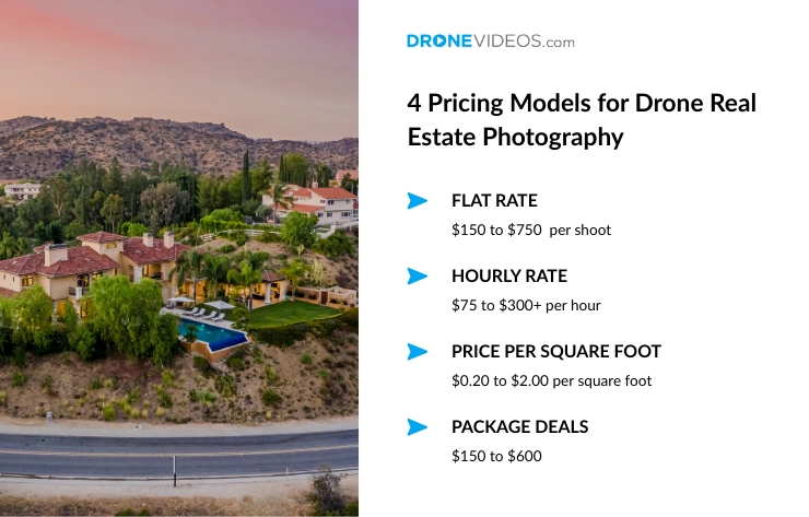
4 pricing models for drone real estate photography:
- Flat Rate
In a flat-rate pricing model, the cost for drone real estate photography ranges between $150 to $750 per shoot, with basic photo packages starting around $150-$250 and premium packages including video reaching $500-$750 or more. The pricing rate in this model is predetermined and fixed regardless of the time or effort involved. This means the client pays a set price for a complete package of services, which might include drone photography, video footage, and basic editing. Additionally, the total costs vary by property size, location, photographer experience, and deliverables. - Hourly Rate
Hourly rates for drone real estate photography range from $75 to $300+ per hour, varying significantly with pilot experience, location, and project complexity. Beginners or less experienced drone real estate photographers typically charge $75 to $150 per hour, while experienced professionals in high-demand can charge $150 to $300 per hour. While this model offers flexibility, it can also lead to unpredictable costs, especially for larger or more complex shoots. For larger or more complex shoots, the cost can quickly escalate as more time is required on-site and for post-production work. - Price Per Square Foot
In the price-per-square-foot pricing model, the cost is determined by the property’s size, making it ideal for larger homes or commercial properties. The costs for the price per square foot model range from $0.20 to $2.00 per square foot. Smaller properties may cost $0.20 to $0.50 per square foot, while larger or more complex properties can cost $0.50 to $2.00 per square foot. This model is scalable, but for larger properties with complex layouts, additional time or equipment may be required, which may not be fully accounted for in the basic price-per-square-foot rate. - Package Deals
Drone real estate photography packages typically range from $150 to $600, depending on the number of images, video inclusion, and the level of editing required. The cost can also be influenced by the property’s size and any additional services, such as drone video or virtual tours. These packages are often more affordable than hourly or flat-rate pricing, making them a great option for clients on a budget. However, not all photographers offer package deals, so be sure to confirm the details with the photographer before scheduling your shoot.
What Factors Influence Drone Real Estate Photography Cost?
Several factors influence the cost of drone real estate photography, including the photographer’s experience, property size, location, equipment used, weather conditions, licensing, and more. Understanding these factors will help you make informed decisions when planning a drone real estate photography shoot.
Factors influencing drone real estate photography cost:
- Experience Level of Drone Photographer
The experience level of a drone real estate photographer can impact the cost, as experienced photographers typically charge higher rates because of their expertise and efficiency. While they might be more expensive, their experience ensures quality, faster turnarounds, making them a valuable investment for premium properties or more complex shoots.
- Property Size
Larger properties and luxury homes require more time for aerial shots, as the drone real estate photographer needs to capture multiple angles and more footage. This means longer flight times and more post-production editing are involved, increasing the overall cost. Whereas smaller properties have lower costs since they require fewer images or videos and less time on-site.
- Geographic Location
In areas with high demand for drone photography services, such as urban centers, pricing is generally higher due to increased competition and operational costs. On the other hand, in more remote or hard-to-reach locations, travel expenses, such as fuel, lodging, and additional time on-site, can raise the cost of the service.
- Volume of Content
If you need a larger number of photos or videos, including multiple angles or extended footage, the drone real estate photographer will need more time to capture the content and edit it accordingly, increasing the cost. Additionally, a larger volume of content may also require more sophisticated equipment, further raising the cost of the project.
- Weather Conditions
Weather conditions such as high winds, rain, or cloudy skies can have a direct impact on the cost of drone photography. This type of weather can create delays and potentially require rescheduling the shoot for better weather, leading to higher costs. For example, a photographer may need to take extra time to ensure safety and quality, which can add to the total cost.
- Equipment Used
High-end drones equipped with advanced features, such as 4K video capability, gimbals, or specialized cameras, require significant investment. As a result, drone real estate photographers who use top-tier equipment typically charge higher rates to cover the costs of these tools, as well as the expertise required to operate them.
- Licensing and Certifications
Drone operators must adhere to strict licensing and certification requirements, particularly in the United States, where the FAA (Federal Aviation Administration) regulates drone usage. Certified drone pilots, specifically with FAA Part 107 certification, typically charge more due to their expertise, compliance with safety standards, and the legal authorization to operate in various conditions.
- Turnaround Time
If you require a faster delivery, such as completing the project within a short timeline or on a rush order, expect to pay higher prices. The photographer may need to expedite the editing process or dedicate more hours to the project to meet the deadline. Quick turnaround times can also limit the photographer’s availability, making it more costly.
- FAA Regulations
FAA-certified drone pilots charge higher rates to cover compliance costs, including registration, insurance, and safety measures. They follow strict regulations, such as altitude limits and no-fly zones, ensuring a safe and legal shoot, which contributes to higher prices for certified operators.
- Insurance Coverage
Drone real estate photographers with insurance coverage charge higher rates to account for premiums, protecting against potential damages or accidents. This added security ensures both the photographer and client are safeguarded, offering peace of mind that any incidents will be appropriately handled during the shoot.
What Are Some Tips to Reduce Drone Real Estate Photography Costs?
To reduce drone real estate photography costs, book during the off-season, opt for bundled services, and be completely flexible with your booking for a better rate. Additionally, focus only on the features you need instead of unwanted premium add-ons. Following this, you can save some extra money on both the shoot and post-production for your next real estate drone photography.
6 tips to reduce drone real estate photography costs:
- Book During Off-Peak Seasons: Prices can be lower mid-week when demand for drone photography is lower.
- Bundle Services: Opt for package deals that include both photos and videos, as bundling drone real estate photography services can often result in a lower overall price.
- Choose Flexible Pricing Models: Look for drone real estate photographers who offer flexible pricing options, such as hourly rates or package deals, to find a model that suits your budget.
- Plan Ahead: Scheduling shoots in advance can help avoid rush fees and additional charges for expedited services.
- Limit the Volume of Content: Reducing the number of photos or videos you need can lower costs, especially for large properties.
- Be Flexible with Timing: If weather conditions are unfavorable, being flexible with rescheduling can help avoid delays that might increase costs.
While it is important to manage costs, ensure you are not compromising on the quality or safety of your shoot by cutting too many corners. Therefore, always prioritize working with certified, experienced professionals for the best real estate drone photography.